

Notices to Mariners
February 23, 2024
Safety First, Service Always
Monthly Eastern Edition
CONTENTS
| Section 1 | General and Safety Information |
| Section 1A | Temporary and Preliminary Notices |
| Section 2 | Chart Corrections |
| Section 3 | Radio Aids to Marine Navigation Corrections |
| Section 4 | Canadian Sailing Directions Corrections |
| Section 5 | List of Lights, Buoys and Fog Signals Corrections |
Notices to Mariners – Monthly Eastern Edition
Edition No. 02/2024
Aussi disponible en français :
Avis aux navigateurs – Édition mensuelle de l’Est
Édition n° 02/2024
Published under the Authority of:
Canadian Coast Guard Programs
Aids to Navigation and Waterways
Fisheries and Oceans Canada
Montreal, QC H2Y 2E7
For more information, contact Notmar.XNCR@dfo-mpo.gc.ca.
© His Majesty the King in Right of Canada,
as represented by the Minister of Fisheries, Oceans
and the Canadian Coast Guard, 2024.
Cat. No. Fs152-8E-PDF (Electronic PDF, English)
ISSN 2817-0075
Cat. No. Fs152-8F-PDF (Electronic PDF, French)
ISSN 2817-0083

Explanatory Notes – Notices to Mariners (NOTMAR)
Geographical positions refer directly to the graduations of the largest scale Canadian Hydrographic Service chart (unless otherwise indicated).
Bearings refer to the true compass and are measured clockwise from 000° (North) clockwise to 359°; those relating to lights are from seaward.
Visibility of lights is that in clear weather.
Depths - The units used for soundings (metres, fathoms or feet) are stated in the title of each chart.
Elevations are normally given above Higher High Water, Large Tide (unless otherwise indicated).
Distances may be calculated as follows:
1 nautical mile = 1,852 metres (6,076.1 feet)
1 statute mile = 1,609.3 metres (5,280 feet)
1 metre = 3.28 feet
Temporary and Preliminary Notices to Mariners – Section 1A of Notices to Mariners
These notices are indicated by a (T) or a (P), respectively. Please note that nautical charts are not amended by the Canadian Hydrographic Service for temporary (T) and preliminary (P) notices. It is recommended that mariners chart these corrections in pencil. For the list of charts affected by (T) & (P) notices, please refer to the current Notices to Mariners - Monthly Summary of Temporary and Preliminary Notices publication.
Suggestions and Corrections Form
This form is specifically for suggestions and corrections to Notices to Mariners publications. It is available online and also in fillable PDF format included with the monthly publication ZIP file.
To submit comments and suggestions on possible improvements to the various publications and services: Notmar.XNCR@dfo-mpo.gc.ca.
To report chart discrepancies and/or corrections to the Canadian Sailing Directions booklets: Fill out the Marine Information Reporting Form and/or email chsinfo@dfo-mpo.gc.ca.
To report emergencies or navigational hazards: Contact your nearest MCTS centre
- VHF channel 16 (156.8 MHz)
- MF/HF frequency 2182 kHz/4125 kHz (where available)
- ∗16 on a cellphone (where available)
NOTMAR Website – Monthly Editions, Chart Corrections and Chart Patches
The NOTMAR website allows users to access the monthly publications,
chart corrections, and chart patches.
Users can subscribe for free to the email notification service
to receive notifications when charts of interest are updated, including their patches, as well as when a new Monthly Edition of Notices to Mariners is published.
In addition, the monthly publication and related
files to download, such as chart patches, can be obtained
all together through the download of a single ZIP file.
Explanatory Notes – Canadian Hydrographic Service (CHS)
Chart Corrections – Section 2 of Notices to Mariners
Corrections to nautical charts will be listed in numerical order by chart number. Each chart correction listed applies only to that particular chart. Related charts, if any, will have their own specific correction listed separately.
Users should also refer to CHS Chart 1: Symbols, Abbreviations and Terms for additional information pertaining to the correction of charts.
The illustration below describes the elements that will comprise a typical Section 2 chart correction:
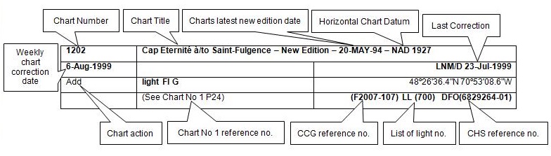
The last correction number is identified with the LNM/D or Last Notice to Mariners Number / Date.
Mariners are advised that only the most critical changes that directly affect safety to navigation are issued in “Section 2 – Chart Corrections.” This limitation is required to ensure that charts remain as clear and easy to read as possible. As a result, mariners may see minor discrepancies of a non-critical nature between information in official publications. For example, a small change in the nominal range or focal height of a light may not result in the production of a chart correction in Notices to Mariners, but may result in a correction in the List of Lights, Buoys and Fog Signals publication.
Note: In the case of a discrepancy between information provided on CHS charts relating to aids to navigation, and the List of Lights, Buoys and Fog Signals publication, the latter shall be deemed as containing the most up-to-date information.
Canadian Nautical Charts & Publications
A source list of Canadian nautical charts and publications is published in Notice No. 14 of the Notices to Mariners Annual Edition 2024. The source supply and the prices effective at the time of printing are listed. For current chart edition dates, please refer to the following website: www.chs-shc.gc.ca/charts-cartes/paper-papier/index-eng.asp
Explanatory Notes – Marine Communications and Traffic Services (MCTS)
Navigational Warnings / Notices to Shipping
The Canadian Coast Guard (CCG) is implementing a number of changes to the aids to navigation system in Canada.
These changes are advertised as Navigational Warnings, formerly called Notices to ShippingFootnote 1, that are broadcast by the CCG, and are then followed up with Notices to Mariners, then charts are updated by hand correction, reprints or new editions.
Mariners are advised that all relevant Navigational Warnings (NAVWARN) should be kept until superseded by Notices to Mariners or through revised charts issued by the Canadian Hydrographic Service (CHS).
NAVWARN are accessible on the applicable regional page on the CCG Navigational Warnings website at http://nis.ccg-gcc.gc.ca.
CHS is reviewing the impact of these changes with CCG and together are preparing an action plan on the issuing of chart revisions.
For further information, contact your regional NAVWARN Issuing Desk.
Atlantic Region (North)
* Port aux Basques MCTS Centre
“N” Series NAVWARN
Canadian Coast Guard
49 Stadium Rd.
P.O. Box 99
Port aux Basques, NL A0M 1C0
Telephone: 709-695-2168 or 1-800-563-9089
Facsimile: 709-695-7784
Email: NAVWARN.MCTSPortAuxBasques@innav.gc.ca
Central Region
* Prescott MCTS Centre
“Q” and “C” Series NAVWARN
Canadian Coast Guard
401 King Street West
P.O. Box 1000
Prescott, ON K0E 1T0
Telephone: 613-925-0666
Facsimile: 613-925-4519
Email: NAVWARN.MCTSPrescott@innav.gc.ca
Atlantic Region (South)
* Sydney MCTS Centre
“M” Series NAVWARN
Canadian Coast Guard
1190 Westmount Road
Sydney, NS B1R 2J6
Telephone: 902-564-7751 or 1-800-686-8676
Facsimile: 902-564-7662
Email: NAVWARN.MCTSSydney@innav.gc.ca
Arctic Region
* Iqaluit MCTS Centre
Operational from approximately mid-May until late December.
“A” Series NAVWARN
Canadian Coast Guard
P.O. Box 189
Iqaluit, NU X0A 0H0
Telephone: 867-979-5269
Facsimile: 867-979-4264
Email: NAVWARN.MCTSIqaluit@innav.gc.ca
* Service available in English and French.
Index
Numerical Index of Canadian Charts Affected
This numerical index lists all nautical charts mentioned in this monthly edition of Notices to Mariners. Only charts appearing in Section 2 of this publication require a chart correction. The appearance of charts in all other sections, particularly those related to the correction of other nautical publications, is included here for reference.
| 1203 | 2307 | 4381 | 5024 |
| 1220 | 2315 | 4468 | 5032 |
| 1221 | 2326 | 4485 | 5047 |
| 1226 | 4011 | 4486 | 5048 |
| 1310 | 4012 | 4491 | 5052 |
| 1313 | 4015 | 4515 | 5164 |
| 1316 | 4020 | 4518 | 5165 |
| 1320 | 4022 | 4641 | 5179 |
| 1351 | 4026 | 4665 | 5300 |
| 1430 | 4114 | 4680 | 5412 |
| 1509 | 4115 | 4701 | 5450 |
| 1550 | 4116 | 4702 | 5452 |
| 2085 | 4118 | 4731 | 6022 |
| 2251 | 4203 | 4823 | 6100 |
| 2260 | 4237 | 4850 | 6428 |
| 2297 | 4255 | 4913 | 7661 |
| 2301 | 4320 | 4920 | 8006 |
| 2302 | 4363 | 4940 |
SECTION 1 - GENERAL AND SAFETY INFORMATION
*505/23Canadian Hydrographic Service – Magnetic Declination Calculations
(Recurrent publication of notice *505/23, originally published in the Notices to Mariners – Monthly Eastern Edition 05/2023 publication.)
Mariners are advised that CHS has adopted the harmonized World Magnetic Model (WMM), as found on the NCEI/NOAA website. Old compass rose declination information on CHS navigational products can be updated using this website: https://www.ngdc.noaa.gov/geomag/calculators/magcalc.shtml#declination. While the differences in the model declinations are small each year, they can become more significant over a large period of time.
*1207/23Canadian Hydrographic Service – Inappropriate Geographical Names Review Process
(Recurrent publication of notice *1207/23, originally published in the Notices to Mariners – Monthly Eastern Edition 12/2023 publication.)
The records of the Canadian Hydrographic Service could contain geographical names that may be considered inappropriate, offensive and derogatory. Geographical naming authorities are in the process of addressing many offensive place names, the review process is underway. For more information, about inappropriate geographical names, please see the following announcement.
*201/24Canadian Hydrographic Service – Nautical Charts
|
Charts |
Main Title |
Scale |
Edition Date |
Published |
Cat# |
Price |
|
New Editions |
||||||
|
1226 |
Mouillages et Installations Portuaires/Anchorages and Harbour Installations - Haute Côte-Nord |
1:50 000 |
2024-01-12 |
2024-02-16 |
1 |
$20.00 |
*202/24Canadian Hydrographic Service – Electronic Navigational Charts
|
S-57 ENC Number |
Chart Title |
ENC Compilation Scale |
Published |
|
New Editions |
|||
|
CA376167 (Edn 8.000) |
Cape Smoky to St. Paul Island |
1:37 500 |
2024-02-23 |
|
CA45RRRA (Edn 2.000) |
Transit5100N05900W |
1:11 000 |
2024-02-23 |
*203/24Transport Canada - Ship Safety Bulletins #04 and #05/2024
New Ship Safety Bulletins have recently been
posted on the
Transport Canada website.
To view or download these bulletins, please click on the
links below:
SSB#04/2024 – Guidelines to
safely transport electric vehicles on Canadian
ferries
RDIMS#
19960265
SSB#05/2024 – Reporting
requirements for the Canadian Carbon Intensity
Indicator
RDIMS#
20036193
Sign up for e-Bulletin to receive an e-mail notice each time a new Ship Safety Bulletin is published on our website.
Contact us at marinesafety-securitemaritime@tc.gc.ca or 1-855-859-3123 (Toll Free).
*204/24Canadian Coast Guard Publication – Annual Edition of Notices to Mariners 2024
The Annual Edition of Notices to Mariners 2024 is now available for free download, on the NOTMAR website.
Paper copies of this publication are no longer sold. This printable online version is kept up to date.
Amendments to this publication are advertised in Section 1 of the monthly editions of Notices to Mariners.
The 2024 edition has been revised up to February 22, 2024 and supersedes the 2023 edition.
*205/24Canadian Coast Guard Publication – Amendements to the Ice Navigation in Canadian Waters (GCC/6120) – Section 4.6.3 Icebreaking Escort Operations
Page
98
AMEND AS FOLLOWS:
4.6.3Icebreaking escort operations
m)Red warning lights and air horn:
[…]
As an additional warning signal, all icebreakers are fitted with and use a zet-horn, facing aft, audible up to 2 nautical miles, which sounds simultaneously with the red warning lights when they are activated. Prior to commencement of escort, all vessels will familiarize themselves with the positioning and operation of these red rotating lights and the zet-horn.
*209/24Lac Saint-Louis – Unlit Buoy Modified
Reference chart: 1430
The aid ID of following unlit buoy has been modified :
|
Aid Name |
LL # |
Position |
|
Canal Lachine buoy P498 |
6192 |
45° 25’ 49.1”N 073° 40’ 16.3”W |
(Q2024-035)
*210/24Lac Saint-Louis – Unlit Buoys Permanently Established
Reference chart: 1430
The following unlit buoys have been permanently established at the following coordinates:
|
Aid Name |
LL # |
Position |
|
Canal Lachine buoy P500 |
6192.005 |
45° 25’ 48.0”N 073° 40’ 22.4”W |
|
Canal Lachine buoy P503 |
6192.07 |
45° 25’ 48.0”N 073° 40’ 18.1”W |
|
Canal Lachine buoy P509 |
6192.22 |
45° 25’ 50.9”N 073° 40’ 43.0”W |
|
Canal Lachine buoy P513 |
6192.31 |
45° 25’ 51.6”N 073° 40’ 50.2”W |
(Q2024-034, 036, 037 038)
*211/24Rivière des Prairies – Unlit Buoys Repositioned
Reference chart: 1509
The following unlit buoys have been repositioned to the following coordinates:
|
Aid Name |
LL # |
Position |
|
Pont Le Gardeur |
11271 |
45° 42’ 12.0”N 073° 29’ 00.8”W |
|
Pont Le Gardeur |
11272 |
45° 42’ 13.4”N 073° 29’ 00.9”W |
|
Pont Le Gardeur |
11273 |
45° 42’ 13.4”N 073° 29’ 01.8”W |
|
Pont Le Gardeur |
11274 |
45° 42’ 12.0”N 073° 29’ 01.7”W |
|
Pont Le Gardeur |
11686 |
45° 42’ 44.8”N 073° 28’ 43.0”W |
|
Pont Le Gardeur |
11687 |
45° 42’ 44.0”N 073° 28’ 44.6”W |
|
Pont Le Gardeur |
11688 |
45° 42’ 44.5”N 073° 28’ 45.1”W |
|
Pont Le Gardeur |
11689 |
45° 42’ 45.3”N 073° 28’ 43.5”W |
(Q2024-048, 050, 052, 054, 056 to 059)
*212/24Lac Saint-Jean – Unlit Buoys Permanently Established
Reference chart: 6100
The following unlit buoys have been permanently established at the following coordinates:
|
Aid Name |
LL # |
Position |
|
La Belle Rivière buoy PRIV |
12898 |
48° 29’ 17.4”N 071° 47’ 54.9”W |
|
La Belle Rivière buoy PRIV |
12899 |
48° 29’ 17.4”N 071° 47’ 51.5”W |
|
La Belle Rivière buoy PRIV |
12900 |
48° 29’ 16.4”N 071° 47’ 51.8”W |
|
La Belle Rivière buoy PRIV |
12901 |
48° 29’ 16.0”N 071° 47’ 49.0”W |
|
La Belle Rivière buoy PRIV |
12902 |
48° 29’ 15.1”N 071° 47’ 49.7”W |
|
La Belle Rivière buoy PRIV |
12903 |
48° 29’ 14.0”N 071° 47’ 46.8”W |
|
La Belle Rivière buoy PRIV |
12904 |
48° 29’ 13.2”N 071° 47’ 48.5”W |
|
La Belle Rivière buoy PRIV |
12905 |
48° 29’ 11.9”N 071° 47’ 47.7”W |
|
La Belle Rivière buoy PRIV |
12906 |
48° 29’ 11.6”N 071° 47’ 44.0”W |
|
La Belle Rivière buoy PRIV |
12907 |
48° 29’ 10.2”N 071° 47’ 44.6”W |
|
La Belle Rivière buoy PRIV |
12908 |
48° 29’ 11.1”N 071° 47’ 39.1”W |
|
La Belle Rivière buoy PRIV |
12909 |
48° 29’ 09.5”N 071° 47’ 38.0”W |
|
La Belle Rivière buoy PRIV |
12910 |
48° 29’ 11.4”N 071° 47’ 36.1”W |
|
La Belle Rivière buoy PRIV |
12911 |
48° 29’ 11.1”N 071° 47’ 32.3”W |
|
La Belle Rivière buoy PRIV |
12912 |
48° 29’ 10.5”N 071° 47’ 33.8”W |
|
La Belle Rivière buoy PRIV |
12913 |
48° 29’ 09.0”N 071° 47’ 30.8”W |
|
La Belle Rivière buoy PRIV |
12914 |
48° 29’ 09.4”N 071° 47’ 32.7”W |
|
La Belle Rivière buoy PRIV |
12915 |
48° 29’ 06.5”N 071° 47’ 31.1”W |
|
La Belle Rivière buoy PRIV |
12916 |
48° 29’ 06.5”N 071° 47’ 32.3”W |
|
La Belle Rivière buoy PRIV |
12917 |
48° 29’ 03.2”N 071° 47’ 32.5”W |
|
La Belle Rivière buoy PRIV |
12918 |
48° 29’ 04.3”N 071° 47’ 33.6”W |
|
La Belle Rivière buoy PRIV |
12919 |
48° 29’ 00.9”N 071° 47’ 36.0”W |
|
La Belle Rivière buoy PRIV |
12920 |
48° 29’ 01.3”N 071° 47’ 37.0”W |
|
La Belle Rivière buoy PRIV |
12921 |
48° 28’ 58.3”N 071° 47’ 40.3”W |
(Q2024-062 to 072, 075 to 087)
Section 1A: Temporary and Preliminary Notices
Reminder – Comment Period for Active Preliminary Notices
This is a reminder that the comment period is still open for the following active Preliminary notices:
|
Notice # |
Reference Chart # |
Aids Affected |
Intent of Notice |
|
Newfoundland and Labrador Coast |
|||
|
4850 |
474.1 |
Light Buoy to be Discontinued |
|
|
Atlantic Coast |
|||
|
4118 |
215 |
Aid to Navigation to be Discontinued |
|
|
4203 |
List |
Notice of Proposed Changes |
|
|
Inland Waters |
|||
|
5412 |
2553 |
Aid to Navigation to be Discontinued |
|
|
7661 |
List |
Aids to Navigation to be Discontinued |
|
Please refer to the Notices to Mariners - Monthly Summary of Temporary and Preliminary Notices publication for details.
Newfoundland and Labrador Coast
Temporary Notices
No notices applicable for this edition.
Preliminary Notices
No notices applicable for this edition.
Atlantic Coast
Temporary Notices
*213/24Île du Petit Mécatina aux/to Îles Sainte-Marie – Waterway Information : Shoal Charted
Reference: Notice 810(T)/22 is cancelled (Chart 4468).
Rocky shoal located at the entrance to Harrington Harbour has been charted.
*214(T)/24Batiscan au/to Lac Saint-Pierre – Waterway Information: Shallow Depths Reported
Reference: Notice 313(T)/23 is cancelled (Chart 1313).
Reference chart: 1313
A shallower depth of 10.4 metres is located at the following positions:
|
46° 19.997' N |
072° 32.698' W |
|
46° 19.993' N |
072° 32.675' W |
|
46° 19.983' N |
072° 32.682' W |
|
46° 19.980' N |
072° 32.703' W |
|
46° 19.985' N |
072° 32.718' W |
A shallower depth of 10.6 metres is located at the following positions:
|
46° 19.978' N |
072° 32.731' W |
|
46° 19.979' N |
072° 32.701' W |
|
46° 19.970' N |
072° 32.703' W |
|
46° 19.971' N |
072° 32.732' W |
A shallower depth of 10.4 metres is located at the following positions:
|
46° 19.983' N |
072° 32.785' W |
|
46° 19.982' N |
072° 32.747' W |
|
46° 19.973' N |
072° 32.752' W |
|
46° 19.972' N |
072° 32.768' W |
|
46° 19.971' N |
072° 32.792' W |
(NW-Q-1338-23)
Preliminary Notices
Atlantic Region
|
Comment
Submission |
Comments should be directed to the following:
Superintendent, |
*215(P)/24Northumberland Strait Central Portion - Ports/Harbours – Notice of Proposed Changes
Reference chart: 4940
The Canadian Coast Guard proposes to permanently change the following aids to navigation:
|
Aid Name |
LL # |
Position |
Proposed Changes |
|
Fixed Aids |
|||
|
Pictou Island (West End) |
897 |
45° 48’ 15.0”N |
Change flash characteristics to: Fl 2 s; Ec 4 s. |
|
Pictou Island Breakwater |
898 |
45° 48’ 09.5”N |
Change flash characteristics to: Fl 2 s; Ec 2 s. |
|
Pictou Island South |
899 |
45° 48’ 13.6”N |
Discontinue aid to navigation. |
|
Pictou Island (East End) |
899.5 |
45° 48’ 55.2”N |
Change flash characteristics to: Fl 1 s; Ec 4 s. |
|
Floating Aid |
|||
|
Pictou Island |
896.95 |
45° 49’ 24.9”N |
Establish a north cardinal buoy equipped with a white
lantern with flash characteristics: |
Initial publication date: Friday, February 23, 2024
Comment submission
deadline: Thursday, May 30, 2024
(G2024-001)
Inland Waters
Temporary Notices
*216(T)/24Canadian Coast Guard – Obstruction : Scientific Moorings
Scientific moorings established at position 71° 58’ 01.2”N 095° 03’ 52.8”W. Least depth 122.8 metres.
(NAVAREA XVIII 32/2011)
Preliminary Notices
No notices applicable for this edition.
SECTION 2 - CHART CORRECTIONS
1220 - Baie des Sept-Îles - New Edition - 24-MAR-2021 - NAD 1983
(See Chart 1, I10)
1220 - Sept-Îles - New Edition - 24-MAR-2021 - NAD 1983
(See Chart 1, I10)
(See Chart 1, I10)
(See Chart 1, I10)
(See Chart 1, I10)
(See Chart 1, I10)
(See Chart 1, I10)
(See Chart 1, I10)
(See Chart 1, I10)
1221 - Pointe de Moisie à/to Île du Grand Caoui - New Edition - 01-APR-2022 - NAD 1983
(See Chart 1, K46.2)
1320 - Île du Bic au/to Cap de la Tête au Chien - New Chart - 26-AUG-2011 - NAD 1983
(See Chart 1, I10)
(See Chart 1, I10)
(See Chart 1, I10)
(See Chart 1, I10)
(See Chart 1, I10)
(See Chart 1, I10)
(See Chart 1, I10)
(See Chart 1, I10)
(See Chart 1, I10)
(See Chart 1, I10)
1509 - Rapides du Cheval Blanc - Sheet/Feuille 1 - New Edition - 15-NOV-2019 - NAD 1983
Download Patch - https://www.notmar.gc.ca/chsftp/patches/1509_6410885_5_202312151000.pdf
1509 - Île Bizard à/to Pont-Viau A-B - Sheet/Feuille 1 - New Edition - 15-NOV-2019 - NAD 1983
(See Chart 1, Qc)
(See Chart 1, Qc)
(See Chart 1, Qc)
(See Chart 1, Qb)
1509 - Île Bizard à/to Pont-Viau B-C - Sheet/Feuille 1 - New Edition - 15-NOV-2019 - NAD 1983
(See Chart 1, Qc)
(See Chart 1, Qc)
1550 - Britannia Bay à/to Breckenridge - Sheet/Feuille 1 - New Edition - 27-MAY-2011 - NAD 1983
(See Chart 1, P1)
2085 - Toronto Harbour - New Edition - 04-MAR-2011 - NAD 1983
(See Chart 1, P1)
to 43°37′54.1″N 079°24′17.9″W
(See Chart 1, P1)
to 43°37′54.2″N 079°24′18.6″W
(See Chart 1, K40)
2251 - Meldrum Bay to/à St.Joseph Island - New Chart - 11-APR-1986 - NAD 1927
(See Chart 1, R13, R20)
2297 - Duck Islands to DeTour Passage - New Edition - 25-MAR-2016 - Unknown
(See Chart 1, R13, R20)
2301 - Passage Island to/à Thunder Bay - New Edition - 22-FEB-1991 - US Standard Datum
(See Chart 1, P65)
2302 - St. Ignace Island to/à Passage Island - New Edition - 02-AUG-1985 - US Standard Datum
(See Chart 1, P65)
4011 - Approaches to / Approches à Bay of Fundy / Baie de Fundy - New Edition - 03-JAN-2003 - NAD 1983
(See Chart 1, L25)
(See Chart 1, I10)
(See Chart 1, I10)
4012 - Yarmouth to / à Halifax - New Edition - 14-FEB-2003 - NAD 1983
(See Chart 1, L25)
(See Chart 1, L25)
4015 - Sydney to / à Saint-Pierre - New Edition - 28-MAR-2003 - NAD 1983
(See Chart 1, L25)
4020 - Strait of Belle Isle / Détroit de Belle Isle - New Edition - 26-JUL-2002 - NAD 1983
(See Chart 1, P16)
4022 - Cabot Strait and approaches / Détroit de Cabot et les approches - New Edition - 17-JAN-2003 - NAD 1983
(See Chart 1, L25)
(See Chart 1, L25)
(See Chart 1, L25)
4026 - Havre Saint-Pierre et/and Cap des Rosiers à/to Pointe des Monts - New Edition - 23-MAY-2014 - NAD 1983
(See Chart 1, K46.2)
(See Chart 1, I10)
4114 - Campobello Island - New Edition - 24-APR-2015 - NAD 1983
(See Chart 1, I10)
4115 - Passamaquoddy Bay and / et St. Croix River - New Edition - 24-FEB-2012 - World Geodetic System 1984
(See Chart 1, I10)
4116 - Approaches to / Approches à Saint John - New Edition - 31-AUG-2007 - NAD 1983
(See Chart 1, I10)
4203 - Halifax Harbour: Black Point to / à Point Pleasant - New Edition - 28-DEC-2018 - NAD 1983
(See Chart 1, P1)
4237 - Approaches to / Approches de Halifax Harbour - New Edition - 28-MAY-2021 - World Geodetic System 1984
(See Chart 1, P1)
4255 - Georges Bank / Banc de Georges: Eastern Portion / Partie Est - New Chart - 27-JUL-1990 - NAD 1983
(See Chart 1, L25)
4320 - Egg Island to / à West Ironbound Island - New Edition - 26-SEP-1997 - NAD 1983
(See Chart 1, L25)
4363 - Cape Smoky to / à St Paul Island - New Edition - 24-FEB-2017 - NAD 1983
(See Chart 1, L25)
(See Chart 1, L25)
4468 - Havre de Harrington - New Edition - 15-OCT-2021 - NAD 1983
Download Patch - https://www.notmar.gc.ca/chsftp/patches/4468_6410947_18_202401251016.pdf
Download Patch - https://www.notmar.gc.ca/chsftp/patches/4468_6410947_19_202401251017.pdf
4468 - Île du Petit Mécatina aux/to Îles Sainte-Marie - New Edition - 15-OCT-2021 - NAD 1983
(See Chart 1, I10)
(See Chart 1, I10)
(See Chart 1, I10)
(See Chart 1, I10)
(See Chart 1, I10)
(See Chart 1, I10)
(See Chart 1, I10)
(See Chart 1, I10)
(See Chart 1, I10)
(See Chart 1, I10)
(See Chart 1, I10)
(See Chart 1, I10)
(See Chart 1, I10)
4486 - Baie des Chaleurs / Chaleur Bay - New Edition - 19-FEB-1999 - NAD 1983
(See Chart 1, P16)
(See Chart 1, P16)
(See Chart 1, P16)
4491 - Malpeque Bay - New Edition - 13-DEC-2002 - NAD 1983
(See Chart 1, Qc)
to 46°35′09.8″N 063°49′37.9″W
4515 - Hare Bay - New Edition - 20-NOV-1998 - NAD 1983
(See Chart 1, I10)
(See Chart 1, I10)
(See Chart 1, I10)
(See Chart 1, I10)
(See Chart 1, I10)
(See Chart 1, I10)
(See Chart 1, I10)
(See Chart 1, I10)
(See Chart 1, I10)
(See Chart 1, I10)
4518 - Ariege Bay - New Edition - 08-NOV-2002 - NAD 1983
(See Chart 1, I10)
(See Chart 1, I10)
(See Chart 1, I10)
(See Chart 1, I10)
(See Chart 1, I10)
(See Chart 1, I10)
(See Chart 1, I10)
(See Chart 1, I10)
(See Chart 1, I10)
(See Chart 1, I10)
(See Chart 1, I10)
(See Chart 1, I10)
(See Chart 1, I10)
4641 - Channel - Port aux Basques - New Edition - 31-OCT-2014 - NAD 1983
(See Chart 1, I10)
(See Chart 1, I10)
(See Chart 1, I10)
(See Chart 1, I10)
(See Chart 1, I10)
(See Chart 1, I10)
4641 - Port aux Basques - New Edition - 31-OCT-2014 - NAD 1983
(See Chart 1, I10)
4665 - St. Margaret Bay and Approaches / et les approches - New Edition - 04-JUL-2003 - NAD 1983
(See Chart 1, Qb)
(See Chart 1, Qb)
(See Chart 1, Qb)
4680 - Hawkes Bay to / à Ste Geneviève Bay including / y compris St. John Bay - New Edition - 07-NOV-2003 - NAD 1983
(See Chart 1, Qb)
(See Chart 1, Qb)
(See Chart 1, Qb)
4701 - Occasional Harbour - New Edition - 13-DEC-2002 - NAD 1983
(See Chart 1, P1)
to 52°40′18.0″N 055°44′50.0″W
(See Chart 1, P16)
4702 - Corbett Island to / à Ship Harbour Head - New Edition - 28-MAY-2004 - NAD 1983
(See Chart 1, P16)
4731 - Forteau Bay to / à Domino Run - New Edition - 13-JUN-2003 - Unknown
(See Chart 1, P16)
4823 - Cape Ray to / à Garia Bay - New Chart - 16-JAN-2004 - NAD 1983
(See Chart 1, L25)
(See Chart 1, L25)
(See Chart 1, L25)
4913 - Caraquet Harbour, Baie de Shippegan and / et Miscou Harbour - New Chart - 07-AUG-1992 - NAD 1983
(See Chart 1, P16)
4920 - Quai / Wharf Petit-Rocher - New Edition - 14-DEC-2018 - NAD 1983
(See Chart 1, P16)
(See Chart 1, P16)
5024 - Nunaksaluk Island to / à Cape Kiglapait - New Chart - 27-JAN-2006 - NAD 1983
(See Chart 1, P16)
(See Chart 1, P16)
(See Chart 1, P16)
5032 - Approaches to / Approches à White Bear Arm - New Chart - 31-JAN-2003 - NAD 1983
(See Chart 1, P16)
5047 - Winsor Harbour Island to / aux Kikkertaksoak Islands - New Edition - 01-FEB-2002 - NAD 1983
(See Chart 1, P16)
5048 - Cape Harrigan to / aux Kidlit Islands - New Edition - 25-DEC-2015 - NAD 1983
(See Chart 1, P16)
(See Chart 1, P16)
5052 - Seniartlit Islands to / à Nain - New Edition - 24-NOV-2017 - NAD 1983
(See Chart 1, P16)
(See Chart 1, P16)
5164 - Lake Melville - New Chart - 27-MAR-2020 - NAD 1983
(See Chart 1, P16)
(See Chart 1, P16)
5165 - Epinette Point to/à Terrington Basin - New Chart - 28-FEB-2020 - NAD 1983
(See Chart 1, P16)
5179 - Alexis River - New Edition - 10-OCT-2003 - NAD 1983
(See Chart 1, P16)
5300 - Baie D'Ungava / Ungava Bay - New Edition - 28-MAY-2004 - Unknown
(See Chart 1, I10)
(See Chart 1, I10)
5450 - Hudson Strait/Détroit d'Hudson - New Edition - 08-JUL-2005 - Unknown
(See Chart 1, I10)
(See Chart 1, I10)
5452 - Diana Bay - New Edition - 08-JUL-2005 - NAD 1983
(See Chart 1, I10)
(See Chart 1, I10)
6022 - Port Carling - Sheet/Feuille 1 - New Edition - 04-MAR-2005 - NAD 1983
(See Chart 1, Qb)
6428 - Aklavik Channel to Napoiak Channel Including Aklavik Channel to Aklavik (Kilometre 1530 to Kilometre 1597) - New Edition - 24-APR-2020 - NAD 1983
(See Chart 1, Qp)
to 68°12′10.0″N 134°28′11.0″W
(See Chart 1, Q120)
(See Chart 1, Qc)
to 68°05′46.9″N 134°27′54.8″W
8006 - Scotian Shelf / Plate-Forme Néo-Écossaise: Browns Bank to Emerald Bank / Banc de Brown au Banc D'Émeraude - New Edition - 14-FEB-2003 - NAD 1983
(See Chart 1, L25)
SECTION 3 - RADIO AIDS TO MARINE NAVIGATION CORRECTIONS
*218/24Radio Aids to Marine Navigation 2024 (Atlantic, St. Lawrence, Great Lakes, Lake Winnipeg, Arctic and Pacific)
Page 2-20
DELETE AS FOLLOWS:
Table 2-8 - Les Escoumins MCTS/VCF - Broadcasts
|
Time UTC |
Site |
Frequency or Channel |
Contents |
|
… |
… |
… |
… |
|
Continuous |
Lac Daigle
Grosses-Roches |
Ch21B (2021) |
Radiotelephony (French followed by English)
•Weather
for marine forecast areas •Notices to Fish Harvesters (when available). |
|
Mont-Louis |
Ch83b (2083) |
Page 3-16
DELETE AS FOLLOWS
3.8.2.6ECAREG Reports Delivery
ECAREG reports for vessels entering Canadian waters shall be sent using the electronic form.:
ECAREG reports for vessels proceeding to west of 66W or arriving at/departing
from Québec-based ports in the Gulf of St. Lawrence shall be
sent to:
Les Escoumins MCTS Centre
Telephone:
418-233-3483
Facsimile: 418-233-3299
Email: ECAREG.ESCOUMINS@INNAV.GC.CA
SECTION 4 - CANADIAN SAILING DIRECTIONS CORRECTIONS
The following Canadian Sailing Directions volumes have recently been updated on the Canadian Hydrographic Service website.
|
No. |
Title |
|
Atlantic Coast |
|
|
ATL108 |
Gulf of St. Lawrence (Southwest Portion) |
|
ATL109 |
Gulf of St. Lawrence (Northeast Portion) |
|
ATL110 |
St. Lawrence River, Cap Whittle / Cap Gaspé to Les Escoumins and Anticosti Island |
|
ATL111 |
St. Lawrence River, Île Verte to Québec and Fjord du Saguenay |
|
ATL112 |
St. Lawrence River, Cap-Rouge to Montréal and Rivière Richelieu |
|
Central Canada |
|
|
CEN308 |
Rideau Canal and Ottawa River |
|
Pacific Coast |
|
|
PAC201 |
Juan de Fuca Strait and Strait of Georgia |
|
PAC202 |
Discovery Passage to Queen Charlotte Strait and West Coast of Vancouver Island |
|
PAC206 |
Hecate Strait, Dixon Entrance, Portland Inlet and Adjacent Waters and Haida Gwaii |
Each volume includes a section entitled “Record of Changes” which lists all updates that are incorporated during the current calendar year.
SECTION 5 - LIST OF LIGHTS, BUOYS AND FOG SIGNALS CORRECTIONS
The amendments are highlighted and deletions are crossed out. For general and region-specific
information on the List of Lights, click on the following links:
Newfoundland and Labrador Coast,
Atlantic Coast,
Inland Waters and
Pacific Coast.
ATLANTIC COAST
| No. | Name |
Position ----- Latitude N. Longitude W. |
Light Characteristics |
Focal Height in m. above water |
Nominal Range |
Description ----- Height in meters above ground |
Remarks ----- Fog Signals |
|||
|---|---|---|---|---|---|---|---|---|---|---|
BAY OF FUNDY, N.B. – WEST (LL 5 – 114) |
||||||||||
|
47 H4146.4 |
Leonardville Wharf |
Near outer end of wharf. 44 58 17.3 066 57 09.3 |
Iso | G | 4s | 7.8 | 7 |
Cylindrical mast. 6.8 |
Year round. Chart:4114 Edn 02/24 (F24-002) |
|
| 47.5 | Leonardville Breakwater |
Near outer end of
breakwater. 44 58 13.3 066 57 11.3 |
Fl | G | 5s | 6.0 | 2 |
Pipe
tower. 1.8 |
Flash 1 s; eclipse
4 s. Year round. Chart:4114 Edn 02/24 (F24-003) |
|
NOVA SCOTIA, SOUTHEAST COAST (LL 327 – 684.02) |
||||||||||
|
451 H3688 |
Westhaver Island |
Mahone Harbour entrance. 44 26 09.8 064 20 15.3 |
Fl | W | 5s | 9.6 | 7 |
White pyramidal tower
with red
7.6 |
Flash 1 s; eclipse 4 s. Year round. Chart:4381 Edn 02/24 (F24-005) |
|
|
456 H3680 |
Quaker Island |
Off Chester Harbour. 44 30 53.7 064 13 57.2 |
LFl | W | 6s | 30.8 | 4 |
White pyramidal tower
with red
6.2 |
Flash 2 s; eclipse 4 s. Year round. Chart:4381 Edn 02/24 (F24-004) |
|
GASPÉ – CHALEUR BAY (LL 1169.1 – 1426) |
||||||||||
| 1408.5 | Baie de Percé light buoy PRIV |
48 31
16.2 064 12 36.9 |
Fl | R | 4s | ….. | ….. | Red, marked “PRIV”. |
Private
aid. Flash 1 s; eclipse 4 s. Chart:4485 Edn 02/24 (Q24-060) |
|
SAGUENAY RIVER (LL 1773 – 1823.4) |
||||||||||
|
1773 H2106 |
Haut-fond Prince |
Rivière-du-Loup, on
shoal. 48 06 29.6 069 36 51.7 |
Fl | W | 2.5s | 24.6 | 18 |
White
cylindrical tower with red bands.
|
Flash 0.1 s; eclipse 2.4 s. Omnidirectional. Year round. Chart:1203 Edn 02/24 (Q24-040) |
|
ST. LAWRENCE RIVER, RIVIÈRE DU LOUP – SOREL (LL 1823.8 – 2185.1) |
||||||||||
|
1963.1 H2327 |
Pont Pierre-Laporte |
On bridge,
W. side. 46 44 42.1 071 17 26.2 |
Iso | G | 2s | 50.5 | 11 | On bridge. |
Visible westward; obstructed 180° towards the bridge. Operates 24 h. Year round. Chart:1316 Edn 02/24 (Q24-032, 047) |
|
RIVIÈRE RICHELIEU (LL 2190 – 2271.92) |
||||||||||
| 2255 | Chambly |
Downstream entrance
of Chambly canal, northern extremity on approach
wharf. 45 26 58.7 073 17 02.1 |
Fl | W | 4s | ….. | 4 |
Mast. 3.0 |
Seasonal. Chart:1351 Edn 02/24 (Q24-039) |
|
ST. LAWRENCE RIVER, SOREL – PORT DE MONTRÉAL (LL 2272.2 – 2384) |
||||||||||
|
2363 2364H2499 H2499.1 |
Route Maisonneuve-Longue-Pointe range |
| | | | | | | | | | | |
S. end of Grandes battures Tailhandier. 022°38' 477.1 m from front.
45 35 42.3 073 29 34.2 |
F
F
|
W
W
|
…..
…..
|
10.1
23.7
|
11
11
|
Square skeleton tower, orange daymark with black vertical
stripe. Square
skeleton tower, orange daymark with black vertical
stripe.7.2 18.6 |
Visible in line of range. Visible in line of range.Operates 24 h. Year round. Operates 24 h. Year round. Chart:1310 Edn 02/24 (Q23-154, 155, Q24-041, 042) |
| 2365.53 | Quai Bellevue light buoy MT3 |
Boucherville
channel. 45 41 03.1 073 26 55.5 |
Fl | G | 4s | ….. | ….. | Green, marked “MT3”. |
Seasonal. Chart:1310 Edn 02/24 (Q24-073) |
|
|
2366 H2497
2367
H2497.1 |
Traverse de Longue-Pointe range |
| | | | | | | | | | | | | | | | | |
Pointe-du-Marigot. 45 33 42.5 073 29 41.3 169°48' 190.0 m from front. |
Iso Iso |
G G |
2s 2s |
14.0 20.6 |
17 17 |
White cylindrical tower, orange slatwork daymark with black
vertical stripe. 8.9 White cylindrical tower, orange slatwork daymark with black vertical stripe. 13.4 |
Visible in line of range. Horizontal and vertical divergence of 9° and 3°, respectively. Operates 24 h. Emergency mode. Year round. Visible in line of range. Horizontal and vertical divergence of 9° and 3°, respectively. Operates 24 h. Emergency mode. Year round. Chart:1310 Edn 02/24 (Q24-074) |
INLAND WATERS
| No. | Name |
Position ----- Latitude N. Longitude W. |
Light Characteristics |
Focal Height in m. above water |
Nominal Range |
Description ----- Height in meters above ground |
Remarks ----- Fog Signals |
|||
|---|---|---|---|---|---|---|---|---|---|---|
ST. CLAIR RIVER (LL 731.2 – 766.8) |
||||||||||
| 737.5 | Light buoy A22 |
Off Squirrel Island. 42 34 06.5 082 34 29.2 |
Fl | R | 4s | ….. | ….. | Red spar, marked “A22”. |
Year round. Chart:14853(U.S.) Edn 02/24 (B24-004) |
|
LAKE HURON (LL 768 – 813) |
||||||||||
| 771 | Kettle Point Reef light buoy V4 |
NW. of point. 43 14 51.8 082 03 21.8 |
Fl | R | 4s | ….. | ….. | Red spar, marked “V4”. |
Year round. Chart:2260 Edn 02/24 (B24-005) |
|
LAKE SUPERIOR (LL 1082 – 1161) |
||||||||||
| 1082 | Ile Parisienne |
On SW. extremity of island. 46 38 42.9 084 43 26.5 |
Fl | W | 10s | 16.1 | 9 |
White hexagonal tower with red upper
portion. 16.6 |
Flash 1 s; eclipse 9 s. Seasonal. Chart:14884(U.S.) Edn 02/24 (D24-005) |
|
| 1083 | Goulais Bay |
On point. 46 41 46.4 084 31 22.9 |
Fl | W | 4s | 11.7 | 4 |
Cylindrical mast, red and white rectangular
daymark 5.8 |
Seasonal. Chart:2315 Edn 02/24 (D24-006) |
|
| 1084 | Maple Island |
On W. side of island. 46 46 07.7 084 34 51.9 |
Fl | W | 4s | 6.3 | 5 |
Cylindrical
mast, red and white rectangular daymark 4.9 |
Seasonal. Chart:14962(U.S.) Edn 02/24 (D24-004) |
|
| 1087 | Coppermine Point |
On extremity of point. 46 59 02.8 084 47 14.7 |
Fl | W | 4s | 14.4 | 5 |
Cylindrical mast, red and white rectangular daymark. 5.5 |
Seasonal. Chart:2307 Edn 02/24 (D24-007) |
|
| 1088 |
Mamainse Harbour Racon - - (M) X & S Bands |
On N. point of largest island off Mamainse Point. 47 02 15.1 084 47 11.5 |
F | R | ..... | 11.3 | 9 |
Red and white cylindrical tower, red and white triangular
daymark. 9.1 |
Seasonal. Chart:2315 Edn 02/24 (D24-008) |
|
| 1089 | Montreal Point |
On high bluff on point at Montreal River
entrance. 47 14 27.4 084 39 02.4 |
Fl | W | 10s | 39.3 | 5 |
Cylindrical mast, red and white rectangular daymark. 8.1 |
Flash 1 s; eclipse 9 s. Seasonal. Chart:2307 Edn 02/24 (D24-009) |
|
| 1129 | Trowbridge Island |
On summit of island. 48 17 34.0 088 52 22.0 |
Fl | W | 5s | 34.7 | 9 |
White octagonal tower. 11.5 |
Flash every 5 s. Seasonal. Chart:2326 Edn 02/24 (D24-002) |
|
| 1130 | Angus Island |
Near N. end of islands. 48 14 07.9 089 00 26.7 |
Fl | W | 10s | 24.7 | 9 |
Skeleton tower. 15.9 |
Flash 1 s; eclipse 9 s. Seasonal. Chart:2326 Edn 02/24 (D24-003) |
|
Report a problem on this page
- Date modified: