
Archived information
The Standard on Web Usability replaces this content. This content is archived because Common Look and Feel 2.0 Standards have been rescinded.
Archived information is provided for reference, research or recordkeeping purposes. It is not subject to the Government of Canada Web Standards and has not been altered or updated since it was archived.
NOTICES TO MARINERS
PUBLICATION
WESTERN EDITION
Safety First, Service Always
Published Monthly by the
CANADIAN COAST GUARD
www.notmar.gc.ca/subscribe/
CONTENTS
| Section 1 | General and Safety Information |
| Section 2 | Chart Corrections |
| Section 3 | Radio Aids to Marine Navigation Corrections |
| Section 4 | Sailing Directions and Small Craft Guide Corrections |
| Section 5 | List of Lights, Buoys and Fog Signals Corrections |
Canadian Coast Guard Programs
Aids to Navigation and Waterways
Fisheries and Oceans Canada
Montreal, Quebec
H2Y 2E7
© Her Majesty the Queen in Right of Canada, 2018
DFO/2018-2003
Fs152-6E-PDF
ISSN 1719-7708
Disponible en français :
Publication des Avis aux navigateurs
Édition de l'Ouest
Édition mensuelle Nº04/2018
Fisheries and Oceans Canada
Official Publication of the Canadian Coast Guard
DFO/2018-2003
EXPLANATORY NOTES
Geographical positions refer directly to the graduations of the largest scale Canadian Hydrographic chart unless otherwise indicated.
Bearings refer to the true compass and are measured clockwise from 000° (North) clockwise to 359°; those relating to lights are from seaward.
Visibility of lights is that in clear weather.
Depths - The units used for soundings (metres, fathoms or feet) are stated in the title of each chart.
Elevations are normally given above Higher High Water, Large Tide unless otherwise indicated.
Distances may be calculated as follows:
1 nautical mile = 1,852 metres (6,076.1 feet)
1 statute mile = 1,609.3 metres (5,280 feet)
1 metre = 3.28 feet
Temporary & Preliminary Notices are indicated by a (T) or a (P) in Section 1, respectively. Please note that Nautical charts are not amended by the Canadian Hydrographic Service for Temporary (T) and Preliminary (P) Notices. It is recommended that mariners chart these corrections in pencil. The list of charts affected by Temporary and Preliminary Notices are revised and promulgated quarterly in Section 1 of the Monthly Edition.
Please note that, in addition to the temporary and preliminary changes normally advertised as (T) and (P) Notices, there are a few permanent changes to aids to navigation that have been advertised as Preliminary Notices to Mariners while charts are being updated for new editions.
Marine Information Report & Suggestion Sheet
Mariners are requested to notify the responsible authorities when new or suspected dangers to navigation are discovered, changes observed in aids to navigation or corrections to publications are seen
to be necessary. Such communications can be made using the Marine Information Report & Suggestion Sheet inserted on the last
page of each monthly edition of Notices to Mariners.
Canadian Hydrographic Service - Information Published in Section 2 of Notices to Mariners
Mariners are advised that only the most critical changes that directly affect safety to navigation are issued in Section 2 – Chart Corrections. This limitation
is required to ensure that charts remain as clear and easy to read as possible. As a result, mariners may see minor discrepancies of a
non-critical nature between information in official publications. For example, a small change in the nominal range or focal height of a light
may not result in the production of a chart correction in Notices to Mariners, but may result in a correction in the List of Lights, Buoys and
Fog Signals publication.
In case of discrepancy between information provided on CHS charts relating to aids to navigation, and the List of Lights, Buoys and Fog Signals publication, the latter shall be deemed as containing the most up-to-date information.
Canadian Nautical Charts & Publications
A source list of Canadian nautical charts and publications is published in Notice No. 14 of the Notices to Mariners Annual Edition 2018. The source supply and the prices
effective at the time of printing are listed. For current chart edition dates, please refer to the following website:
www.chs-shc.gc.ca/charts-cartes/paper-papier/index-eng.asp
CHART CORRECTIONS - SECTION 2
Corrections to nautical charts will be listed in numerical order by chart number. Each chart correction listed applies only to that particular chart. Related charts, if any, will have their own specific correction listed separately.
Users should also refer to CHS Chart 1: Symbols, Abbreviations and Terms for additional information pertaining to the correction of charts.
The illustration below describes the elements that will comprise a typical Section 2 chart correction:
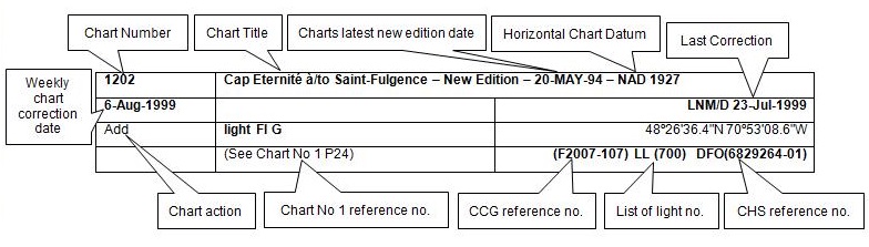
The last correction number is identified with the LNM/D or Last Notice to Mariners Number / Date.
NOTICES TO MARINERS WEBSITE – MONTHLY EDITIONS, CHART CORRECTIONS, AND CHART PATCHES
The Notices to Mariners website allows users to access the monthly publications,
chart corrections, and chart patches.
Users can subscribe for free to the email notification service
to receive notifications when charts of interest are updated, including their patches, as well as when a new monthly edition becomes available online.
ADVISORY NOTICES TO SHIPPING (BROADCAST AND WRITTEN)
The Canadian Coast Guard is implementing a number of changes to the aids to navigation system in Canada.
These changes are advertised as Notices to Shipping (Broadcast and Written) by the Canadian Coast Guard, and are then followed up with Notices to Mariners, then charts are updated by hand correction, reprints or new editions.
Mariners are advised that all relevant Written Notices to Shipping should be kept until superseded by Notices to Mariners or through revised charts issued by the Canadian Hydrographic Service (CHS).
Written Notices to Shipping are available on the Canadian Coast Guard website at: www.ccg-gcc.gc.ca/eng/CCG/NOTSHIP.
The Canadian Hydrographic Service is reviewing the impact of these changes with the Canadian Coast Guard and together are preparing an action plan on the issuing of chart revisions.
For further information, contact your local Regional Notices to Shipping (NOTSHIP) issuing authorities.
Western
MCTS Western Regional Office
Canadian Coast Guard
Institute of Ocean Sciences
P.O. Box 6000
9860 West Saanich Rd.
Sidney, BC V8L 4B2
Telephone: (250) 363-8904 (Regional Administrative Assistant)
Email: NOTSHIP.Western@innav.gc.ca
* Iqaluit MCTS Centre
Operational from approximately mid-May until late December.
Canadian Coast Guard
P.O. Box 189
Iqaluit, NU X0A 0H0
“A” Series NOTSHIPs
Telephone: (867) 979-5269
Facsimile: (867) 979-4264
Email: IqaNordreg@innav.gc.ca
Website:
http://www.ccg-gcc.gc.ca/eng/CCG/Notship-Home
“H” Series NOTSHIPs
Telephone: (867) 979-0310
Facsimile: (867) 979-4264
Email: Iqamck01@innav.gc.ca
Website:
http://www.ccg-gcc.gc.ca/eng/CCG/Notship-Home
* Service available in English and French.
Index
NUMERICAL INDEX OF CANADIAN CHARTS AFFECTED
| 3062 | 3475 | 3668 | 3855 |
| 3313 | 3477 | 3671 | 3910 |
| 3412 | 3478 | 3675 | 3933 |
| 3441 | 3489 | 3676 | 3941 |
| 3442 | 3493 | 3794 | 3960 |
| 3443 | 3513 | 3807 | 6242 |
| 3463 | 3540 | 3808 |
SECTION 1 - GENERAL AND SAFETY INFORMATION
CANADIAN HYDROGRAPHIC SERVICE – ANNOUNCEMENT REGARDING CHS CHART PATCHES
Colour Web Patches are free to the mariner, and given the quality of many printers, should reproduce well. They will be available in real time all around the world.
CHS welcomes your feedback on this service at chsinfo@dfo-mpo.gc.ca
CANADIAN HYDROGRAPHIC SERVICE – CUMULATIVE CHART CORRECTIONS
The cumulative chart corrections published in
Notices to Mariners can now be accessed
at
https://www.notmar.gc.ca/corrections-en.php
CANADIAN HYDROGRAPHIC SERVICE – CURRENT CHART EDITION DATES
CHART
EDITIONS
The three terms
described below are used to indicate the publication status
of Canadian charts.
NEW CHART -
"NEWCHT"
The first
publication of a Canadian chart embracing an area not
previously charted to the scale shown, or embracing an area
different from any existing Canadian chart.
NEW EDITION -
"NEWEDT"
A new issue of
an existing chart containing amendments essential to
navigation in addition to those issued in Notices
to Mariners and making existing editions
obsolete.
REPRINTS
A new
issue of the current edition of a chart incorporating no
amendments of navigational significance other than those
previously promulgated in Notices to
Mariners. It may also contain amendments from
other sources provided they are not essential to navigation.
Previous printings of the current edition remain in
force.
The current chart edition dates can be accessed at www.chs-shc.gc.ca/charts-cartes/paper-papier/index-eng.asp
CANADIAN HYDROGRAPHIC SERVICE – PRINT ON DEMAND CHARTS - CARE AND USE
Background
By providing nautical charts to the public, the goal of the Canadian Hydrographic Service (CHS) is to provide services for safe navigation in a fiscally responsible manner. As a result, CHS continues to expand its portfolio of nautical paper charts that are printed using Print On Demand (POD) technology. These charts are easily recognized by their whiter paper and the coloured logo of the Canadian Hydrographic Service. This new technology enables CHS to print charts in a more efficient manner, while enhancing chart content through being able to quickly add new and important information. POD technology provides customers with up-to-date charts without the historical hand-drawn corrections or glued-on patches. Additionally, this technology eliminates out-of-stock situations which arise with the traditional printing and warehousing methods. In the event of a national emergency, CHS can respond to the appropriate authorities with the best available information very quickly.
Care of Your POD Chart
CHS encourages its customers to handle the POD charts more carefully than the traditional lithographic charts. When plotting information on POD charts, use HB pencils and apply limited pressure. Testing has suggested that an Indian gum eraser is more effective than alternatives when used on the product. This eraser is also suitable for charts printed using lithographic processes.
CANADIAN HYDROGRAPHIC SERVICE, TRANSPORT CANADA – NAVIGATION SAFETY - ECDIS
Mariners are advised that ECDIS may not display some isolated shoal depths when operating in "base or standard display" mode. Route planning and monitoring alarms for these shoal depths may not always be activated. To ensure safe navigation and to confirm that a planned route is clear of such dangers, mariners should visually inspect the planned route and any deviations from it using ECDIS configured to display "all data". The automated voyage planning check function should not be solely relied upon.
CANADIAN HYDROGRAPHIC SERVICE – MODIFICATION TO CATALOGUE 2: PACIFIC COAST/CÔTE PACIFIQUE
The Canadian Hydrographic Service has been recently
informed that there is an error in the following chart
catalogue:
Catalogue 2:
Pacific Coast/Côte pacifique
Affix patch to Catalogue 2: Pacific Coast/Côte
pacifique provided in Section 1 of this monthly
edition.
https://www.notmar.gc.ca/publications/monthly-mensuel/images/ed072017-part1-catalogue2-patch.pdf
CANADIAN HYDROGRAPHIC SERVICE – MODIFICATIONS TO THE 2018 CANADIAN TIDE AND CURRENT TABLES VOLUME 6 – DISCOVERY PASSAGE & WEST COAST OF VANCOUVER ISLAND
The Canadian Hydrographic Service of the Pacific Region has recently been informed that there is an error in the 2018 Canadian Tide and Current Tables Volume 6 - Discovery Passage & West Coast of Vancouver Island, page 120, Index no. 8512 – NEAH BAY.
Mariners should replace the values for Neah Bay,
Index no. 8512 using the attached Table 3 for page
120 provided in
Section 1 of this monthly edition.
https://www.notmar.gc.ca/publications/monthly-mensuel/images/ed012018-part1-tidal-information-vol6-p120.pdf
CANADIAN HYDROGRAPHIC SERVICE – NEW LOCATION TO DOWNLOAD PATCHES
The Canadian Hydrographic Service has moved patch downloads from http://www.chs-shc.gc.ca/patches/ to ftp://ftp.dfo-mpo.gc.ca/patches/. The PDF versions of the monthly editions of Notices to Mariners prior to July 2017 are published with the previous location to download patches, while the HTML versions have the updated hyperlinks to the new location. These changes have also been applied to the “Search Chart Corrections” service on the Notices to Mariners website (https://www.notmar.gc.ca/corrections-en.php).
*401 CANADIAN HYDROGRAPHIC SERVICE – ELECTRONIC NAVIGATIONAL CHARTS
|
S-57 ENC NUMBER |
CHART TITLE |
|---|---|
|
NEW PRODUCTS |
|
|
CA276322 |
Cape Harrison to/à Nunaksaluk Island |
|
CA470613 |
Caamaño to/à Nepean Sound |
|
CA479249 |
Baie de Bonne-Espérance à/to Île Mistanoque |
|
CA573487 |
Ulukhaktok |
|
CA576086 |
St. George's Public Wharf / Quai public |
|
CA576191 |
Little Port |
|
CA576192 |
The Narrows |
|
CA579250 |
Baie Chevalier |
|
CA579251 |
Passe Champlain |
|
CA579252 |
Vieux-Fort |
*402 CANADIAN HYDROGRAPHIC SERVICE – RASTER DIGITAL CHARTS (BSB V3)
|
CHARTS |
MAIN TITLE |
SCALE |
PUBLISHED |
|---|---|---|---|
|
New Charts |
|||
|
RM-3980 |
Laredo Sound |
1:40 000 |
13-JAN-2017 |
|
Charts Permanently Withdrawn |
|||
|
RM-4470 |
Blanc Sablon à/to Middle Bay |
||
|
RM-4471 |
Baie au Saumon à/to Baie des Homards |
||
*403 TRANSPORT CANADA – SHIP SAFETY BULLETIN #04/2018
This is to notify you that a new Ship Safety Bulletin has recently been posted to the Transport Canada website at www.tc.gc.ca/ssb-bsn/.
To go online to view or download this bulletin, please click on the link below:
SSB#04/2018
- Marine Diesel Engines In Small Canadian
Vessels
RDIMS#13634117
Sign yourself up for e-Bulletin to receive an e-mail notice each time a new Ship Safety Bulletin is published on our Website.
Contact us at: marinesafety-securitemaritime@tc.gc.ca or 1-855-859-3123 (Toll Free).
*404 CANADIAN COAST GUARD PUBLICATION – RADIO AIDS TO MARINE NAVIGATION (ATLANTIC, ST. LAWRENCE, GREAT LAKES, LAKE WINNIPEG, ARCTIC AND PACIFIC) – 2018
The 2018 Edition of the Radio Aids to Marine Navigation (Atlantic, St. Lawrence, Great Lakes, Lake Winnipeg, Arctic and Pacific) is now available for download, free of charge, on the Marine Communications and Traffic Services (MCTS) website: http://www.ccg-gcc.gc.ca/Marine-Communications/Home. Paper copies of this publication are no longer sold.
Amendments to this publication are advertised by radio broadcast (Notices to Shipping) and/or in Section 3 of the monthly editions of Notices to Mariners (https://www.notmar.gc.ca/monthly-mensuel-en.php). The 2018 edition has been revised up to April 27th, 2018 and supersedes the 2017 edition.
*407 CANADIAN COAST GUARD - LIST OF CHARTS AND REFERENCE CHARTS (SECTION 1) AFFECTED BY TEMPORARY AND PRELIMINARY NOTICES
IN EFFECT APRIL 27th, 2018
(REVISED AND PROMULGATED QUARTERLY)
|
1430 |
409(P)/18 |
4244 |
1006(T)/14 |
|
1432 |
107(P)/17 |
4266 |
309(P)/18 |
|
2017 |
909(T)/14 |
4302 |
906(P)/17 907(P)/17 |
|
2044 |
1005(T)/15 |
4307 |
908(P)/17 |
|
2060 |
814(T)/16 |
4377 |
405(P)/13 |
|
2067 |
1218(T)/16 |
4406 |
207(P)/18 |
|
2077 |
1011(T)/16 |
4419 |
1204(P)/17 |
|
2085 |
1205(T)/17 112(T)/18 211(T)/18 |
4426 |
310(P)/18 |
|
2086 |
1219(T)/16 |
4443 |
1106(P)/17 1107(P)/17 |
|
2123 |
309(T)/17 |
4459 |
208(P)/18 |
|
2181 |
108(T)/17 |
4460 |
311(P)/18 312(P)/18 |
|
2202 |
109(P)/17 |
4466 |
313(P)/18 314(P)/18 |
|
2235 |
818(T)/16 |
4491 |
1007(P)/17 |
|
2315 |
515(T)/16 |
4523 |
209(P)/18 |
|
3479 |
617(P)/17 |
4587 |
413(P)/18 |
|
3513 |
410(P)/18 |
4591 |
210(P)/18 |
|
3540 |
411(P)/18 |
4642 |
315(P)/18 |
|
3624 |
1116(P)/16 |
4644 |
1106(T)/15 |
|
3646 |
618(P)/17 1010(P)/17 |
4845 |
414(P)/18 |
|
3671 |
620(P)/17 |
4865 |
415(P)/18 |
|
3675 |
1118(P)/16 |
4909 |
613(P)/12 |
|
3676 |
1119(P)/16 |
4911 |
811(P)/12 510(P)/15 |
|
3679 |
1121(P)/16 |
4913 |
518(P)/16 |
|
3681 |
1122(P)/16 |
5047 |
416(P)/18 |
|
3686 |
1123(P)/16 |
6022 |
1206(T)/17 |
|
3890 |
1108(P)/17 |
6218 |
204(T)/16 |
|
4010 |
608(P)/17 |
6242 |
113(T)/18 417(P)/18 418(P)/18 |
|
4116 |
205(P)/18 |
6267 |
114(T)/18 |
|
4117 |
206(P)/18 |
6287 |
113(T)/17 |
|
4236 |
610(P)/15 412(P)/18 |
14853 (U.S.) |
808(P)/17 |
*410(P) STRAIT OF GEORGIA, NORTHERN PORTION/PARTIE NORD – LIGHT TO BE DISCONTINUED
Reference Chart: 3513
The Canadian Coast Guard proposes to permanently discontinue the following aid to navigation:
| Kuhushan Point | (LL 509) | (49° 53’ 19.3’’N 125° 07’ 23.2’’W NAD83) |
Comments on this action are solicited from mariners and other interested parties by July 27th, 2018, three months following the initial publication date of April 27th, 2018. Comments should be directed to the following:
A/Superintendent, Glenna
Evans
Aids to Navigation & Waterways, Western
Region
Canadian Coast Guard
25 Huron Street
Victoria, BC V8V 4V9
Telephone: (250)
480-2602
Fax: (250)
480-2702
Email: glenna.evans@dfo-mpo.gc.ca
Any objections raised must state the facts on which they are based and should include supporting information on safety, commerce and public benefit.
(P2018-057)
*411(P) APPROACHES TO/APPROCHES À CAMPBELL RIVER – DAYBEACON TO BE DISCONTINUED
Reference Chart: 3540
The Canadian Coast Guard proposes to permanently discontinue the following aid to navigation:
| Tyee Spit Breakwater port daybeacon | (LL 5327) | (50° 01’ 58.4’’N 125° 14’ 25.1’’W NAD83) |
Comments on this action are solicited from mariners and other interested parties by July 27th, 2018, three months following the initial publication date of April 27th, 2018. Comments should be directed to the following:
A/Superintendent, Glenna
Evans
Aids to Navigation & Waterways, Western
Region
Canadian Coast Guard
25 Huron Street
Victoria, BC V8V 4V9
Telephone: (250)
480-2602
Fax: (250)
480-2702
Email: glenna.evans@dfo-mpo.gc.ca
Any objections raised must state the facts on which they are based and should include supporting information on safety, commerce and public benefit.
(P2018-057)
*417(P) WINNIPEG TO/AU LAKE WINNIPEG/LAC WINNIPEG – LIGHTS TO BE DISCONTINUED
Reference Chart: 6242
The Canadian Coast Guard proposes to permanently discontinue the following aids to navigation:
| Red River range front | (LL 1562) | (50° 23’ 41.6’’N 096° 48’ 38.0’’W) |
| Red River range rear | (LL 1563) | (163°05' 602.7 m from front.) |
| Red River Mouth West Breakwater | (LL 1563.3) | (50° 24’ 04.3’’N 096° 48’ 51.3’’W) |
| East Breakwall RACON | (LL 9759.5) | (50° 24’ 05.0’’N 096° 48’ 45.7’’W) |
Comments on this action are solicited from mariners and other interested parties by July 27th, 2018, three months following the initial publication date of April 27th, 2018. Comments should be directed to the following:
A/Superintendent, Glenna
Evans
Aids to Navigation & Waterways, Western
Region
Canadian Coast Guard
25 Huron Street
Victoria, BC V8V 4V9
Telephone: (250)
480-2602
Fax: (250)
480-2702
Email: glenna.evans@dfo-mpo.gc.ca
Any objections raised must state the facts on which they are based and should include supporting information on safety, commerce and public benefit.
(A2018-009)
*418(P) WINNIPEG TO/AU LAKE WINNIPEG/LAC WINNIPEG – UNLIT BUOYS PERMANENTLY DISCONTINUED
Reference Chart: 6242
The Canadian Coast Guard has permanently discontinued the following aids to navigation:
| Red River Mouth spar buoy X9 | (LL 9758) | 50º 24’ 47.4’’N 096º 49’ 05.4’’W (NAD83) |
| Red River Mouth buoy X17A | (LL 9764.4) | 50º 23’ 48.2’’N 096º 48’ 40.5’’W (NAD83) |
Comments on this action are solicited from mariners and other interested parties by July 27th, 2018, three months following the initial publication date of April 27th, 2018. Comments should be directed to the following:
A/Superintendent, Glenna
Evans
Aids to Navigation & Waterways, Western
Region
Canadian Coast Guard
25 Huron Street
Victoria, BC V8V 4V9
Telephone: (250)
480-2602
Fax: (250)
480-2702
Email: glenna.evans@dfo-mpo.gc.ca
Any objections raised must state the facts on which they are based and should include supporting information on safety, commerce and public benefit.
(A2018-008, 010)
SECTION 2 - CHART CORRECTIONS
3062 - Pitt River - Sheet/Feuille 1 - New Chart - 24-MAY-1985 - NAD 1927
| 06-APR-2018 | LNM/D. 11-MAR-2011 | ||
| Add |
depth of 6.8 metres (See Chart No. 1, I10) |
49°11′29.7″N 122°43′26.6″W | |
| DFO(6203695-01) | |||
| Add |
depth of 6.1 metres (See Chart No. 1, I10) |
49°11′25.8″N 122°43′25.7″W | |
| DFO(6203695-03) |
3313 - Victoria Harbour - Sheet/Feuille 3 - New Edition - 02-JAN-2009 - NAD 1983
| 20-APR-2018 | LNM/D. 13-APR-2018 | ||
| Add |
submarine cable (See Chart No. 1, L30.1) This notice affects Electronic Navigational Chart: CA570562 |
joining 48°25′42.8″N 123°22′15.1″W 48°25′42.7″N 123°22′18.6″W 48°25′42.7″N 123°22′19.8″W and 48°25′42.5″N 123°22′22.0″W |
|
| DFO(6203714-02) |
3313 - Swanson Channel - Sheet/Feuille 8 - New Edition - 02-JAN-2009 - NAD 1983
| 20-APR-2018 | LNM/D. 13-APR-2018 | ||
| Add |
depth of 1.9 metres (See Chart No. 1, I10) This notice affects Electronic Navigational Chart: CA470005, CA570239 |
48°50′36.1″N 123°27′35.9″W | |
| DFO(6203711-01) |
3313 - Captain Passage - Sheet/Feuille 10 - New Edition - 02-JAN-2009 - NAD 1983
| 20-APR-2018 | LNM/D. 13-APR-2018 | ||
| Add |
depth of 1.9 metres (See Chart No. 1, I10) This notice affects Electronic Navigational Chart: CA470005, CA570239 |
48°50′36.1″N 123°27′35.9″W | |
| DFO(6203711-01) |
3313 - Saanich Inlet - Sheet/Feuille 13 - New Edition - 02-JAN-2009 - NAD 1983
| 13-APR-2018 | LNM/D. 06-APR-2018 | ||
| Add |
obstruction with legend Obstn (See Chart No. 1, K40) This notice affects Electronic Navigational Chart: CA470003 |
48°42′42.8″N 123°33′00.8″W | |
| DFO(6203697-01) | |||
| Delete |
depth of 4.3 metres (See Chart No. 1, I10) This notice affects Electronic Navigational Chart: CA470003 |
48°42′43.9″N 123°33′00.0″W | |
| DFO(6203697-02) |
3313 - Sansum Narrows - Sheet/Feuille 14 - New Edition - 02-JAN-2009 - NAD 1983
| 13-APR-2018 | LNM/D. 06-APR-2018 | ||
| Add |
obstruction with legend Obstn (See Chart No. 1, K40) This notice affects Electronic Navigational Chart: CA470003 |
48°42′42.8″N 123°33′00.8″W | |
| DFO(6203697-01) | |||
| Delete |
depth of 4.3 metres (See Chart No. 1, I10) This notice affects Electronic Navigational Chart: CA470003 |
48°42′43.9″N 123°33′00.0″W | |
| DFO(6203697-02) |
3313 - Stuart Channel South/Sud - Sheet/Feuille 15 - New Edition - 02-JAN-2009 - NAD 1983
| 06-APR-2018 | LNM/D. 09-MAR-2018 | ||
| Add |
rock which covers and uncovers with drying height of 0.4
metres (See Chart No. 1, K11) This notice affects Electronic Navigational Chart: CA470070 |
48°59′16.4″N 123°45′26.5″W | |
| DFO(6203689-01) | |||
| Delete |
depth of 0.3 metres (See Chart No. 1, I10) This notice affects Electronic Navigational Chart: CA370145, CA470070 |
48°59′09.5″N 123°45′02.0″W | |
| DFO(6203689-07) | |||
| Add |
rock which covers and uncovers with drying height of 0.1
metres (See Chart No. 1, K11) This notice affects Electronic Navigational Chart: CA370145, CA470070 |
48°59′09.6″N 123°45′02.6″W | |
| DFO(6203689-08) | |||
| Add |
depth of 3.7 metres (See Chart No. 1, I10) This notice affects Electronic Navigational Chart: CA470070 |
48°59′04.9″N 123°45′15.7″W | |
| DFO(6203689-17) | |||
| Add |
depth of 4.3 metres (See Chart No. 1, I10) This notice affects Electronic Navigational Chart: CA470070 |
48°59′00.6″N 123°45′07.7″W | |
| DFO(6203689-21) | |||
| Add |
depth of 9.5 metres (See Chart No. 1, I10) This notice affects Electronic Navigational Chart: CA470070 |
48°59′02.8″N 123°44′54.0″W | |
| DFO(6203689-22) | |||
| Delete |
depth of 3.0 metres (See Chart No. 1, I10) |
48°59′06.0″N 123°45′13.0″W | |
| DFO(6203689-26) |
3412 - Victoria Harbour - New Edition - 22-NOV-2013 - World Geodetic System 1984
| 20-APR-2018 | LNM/D. 12-JAN-2018 | ||
| Add |
submarine cable (See Chart No. 1, L30.1) This notice affects Electronic Navigational Chart: CA570562 |
joining 48°25′42.8″N 123°22′15.1″W 48°25′42.7″N 123°22′18.6″W 48°25′42.7″N 123°22′19.8″W and 48°25′42.5″N 123°22′22.0″W |
|
| DFO(6203714-02) |
3441 - Haro Strait, Boundary Pass and/et Satellite Channel - New Edition - 01-JUL-2005 - NAD 1983
| 13-APR-2018 | LNM/D. 23-FEB-2018 | ||
| Add |
obstruction with legend Obstn (See Chart No. 1, K40) This notice affects Electronic Navigational Chart: CA470003 |
48°42′42.8″N 123°33′00.8″W | |
| DFO(6203697-01) | |||
| Delete |
depth of 4.3 metres (See Chart No. 1, I10) This notice affects Electronic Navigational Chart: CA470003 |
48°42′43.9″N 123°33′00.0″W | |
| DFO(6203697-02) |
3442 - North Pender Island to/à Thetis Island - New Edition - 01-JUL-2005 - NAD 1983
| 06-APR-2018 | LNM/D. 09-MAR-2018 | ||
| Add |
rock which covers and uncovers with drying height of 0.4
metres (See Chart No. 1, K11) This notice affects Electronic Navigational Chart: CA470070 |
48°59′16.4″N 123°45′26.5″W | |
| DFO(6203689-01) | |||
| Delete |
depth of 0.3 metres (See Chart No. 1, I10) This notice affects Electronic Navigational Chart: CA370145, CA470070 |
48°59′09.5″N 123°45′02.0″W | |
| DFO(6203689-07) | |||
| Add |
rock which covers and uncovers with drying height of 0.1
metres (See Chart No. 1, K11) This notice affects Electronic Navigational Chart: CA370145, CA470070 |
48°59′09.6″N 123°45′02.6″W | |
| DFO(6203689-08) | |||
| Add |
depth of 3.7 metres (See Chart No. 1, I10) This notice affects Electronic Navigational Chart: CA470070 |
48°59′04.9″N 123°45′15.7″W | |
| DFO(6203689-17) | |||
| Delete |
depth of 8.5 metres (See Chart No. 1, I10) This notice affects Electronic Navigational Chart: CA470070 |
48°59′04.3″N 123°45′16.3″W | |
| DFO(6203689-18) | |||
| Add |
depth of 4.3 metres (See Chart No. 1, I10) This notice affects Electronic Navigational Chart: CA470070 |
48°59′00.6″N 123°45′07.7″W | |
| DFO(6203689-21) | |||
| Add |
depth of 9.5 metres (See Chart No. 1, I10) This notice affects Electronic Navigational Chart: CA470070 |
48°59′02.8″N 123°44′54.0″W | |
| DFO(6203689-22) | |||
| 20-APR-2018 | LNM/D. 06-APR-2018 | ||
| Add |
depth of 1.9 metres (See Chart No. 1, I10) This notice affects Electronic Navigational Chart: CA470005, CA570239 |
48°50′36.1″N 123°27′35.9″W | |
| DFO(6203711-01) |
3443 - Thetis Island to/à Nanaimo - New Edition - 20-DEC-2002 - NAD 1983
| 06-APR-2018 | LNM/D. 09-MAR-2018 | ||
| Add |
rock which covers and uncovers with drying height of 0.4
metres (See Chart No. 1, K11) This notice affects Electronic Navigational Chart: CA470070 |
48°59′16.4″N 123°45′26.5″W | |
| DFO(6203689-01) | |||
| Delete |
depth of 0.3 metres (See Chart No. 1, I10) This notice affects Electronic Navigational Chart: CA370145, CA470070 |
48°59′09.5″N 123°45′01.2″W | |
| DFO(6203689-07) | |||
| Add |
rock which covers and uncovers with drying height of 0.1
metres (See Chart No. 1, K11) This notice affects Electronic Navigational Chart: CA370145, CA470070 |
48°59′09.6″N 123°45′02.6″W | |
| DFO(6203689-08) | |||
| Add |
depth of 3.7 metres (See Chart No. 1, I10) This notice affects Electronic Navigational Chart: CA470070 |
48°59′04.9″N 123°45′15.7″W | |
| DFO(6203689-17) | |||
| Delete |
depth of 8.5 metres (See Chart No. 1, I10) This notice affects Electronic Navigational Chart: CA470070 |
48°59′04.3″N 123°45′16.3″W | |
| DFO(6203689-18) | |||
| Add |
depth of 4.3 metres (See Chart No. 1, I10) This notice affects Electronic Navigational Chart: CA470070 |
48°59′00.6″N 123°45′07.7″W | |
| DFO(6203689-21) | |||
| Add |
depth of 9.5 metres (See Chart No. 1, I10) This notice affects Electronic Navigational Chart: CA470070 |
48°59′02.8″N 123°44′54.0″W | |
| DFO(6203689-22) |
3463 - Strait of Georgia, Southern Portion/Partie Sud - New Edition - 01-JUL-2005 - NAD 1983
| 06-APR-2018 | LNM/D. 18-AUG-2017 | ||
| Delete |
depth of 0.3 metres (See Chart No. 1, I10) This notice affects Electronic Navigational Chart: CA370145, CA470070 |
48°59′10.5″N 123°45′01.0″W | |
| DFO(6203689-07) | |||
| Add |
rock which covers and uncovers with drying height of 0.1
metres (See Chart No. 1, K11) This notice affects Electronic Navigational Chart: CA370145, CA470070 |
48°59′09.6″N 123°45′02.6″W | |
| DFO(6203689-08) |
3475 - Ladysmith Harbour - New Edition - 30-DEC-2005 - NAD 1983
| 13-APR-2018 | LNM/D. 14-JUL-2017 | ||
| Affix |
patch Download Patch - ftp://ftp.dfo-mpo.gc.ca/patches/3475_Patch_NTM2018041_Final.pdf This notice affects Electronic Navigational Chart: CA570154 |
48°59′00.0″N 123°45′00.0″W | |
| DFO(6203761-01) |
3477 - Bedwell Harbour to/à Georgeson Passage - New Edition - 03-MAY-1985 - NAD 1927
| 06-APR-2018 | LNM/D. 10-NOV-2017 | ||
| Add |
obstruction with legend Obstn (See Chart No. 1, K40) This notice affects Electronic Navigational Chart: CA570186 |
48°45′37.3″N 123°13′23.5″W | |
| DFO(6203696-01) |
3478 - Ganges Harbour and/et Long Harbour - New Edition - 12-JUL-2013 - NAD 1983
| 20-APR-2018 | LNM/D. 15-JUL-2016 | ||
| Add |
depth of 1.9 metres (See Chart No. 1, I10) This notice affects Electronic Navigational Chart: CA470005, CA570239 |
48°50′36.1″N 123°27′35.9″W | |
| DFO(6203711-01) |
3489 - Pattullo Bridge to/à Barnston Island - Sheet/Feuille 1 - New Chart - 21-OCT-1994 - NAD 1983
| 06-APR-2018 | LNM/D. 01-SEP-2017 | ||
| Add |
depth of 6.8 metres (See Chart No. 1, I10) |
49°11′29.1″N 122°43′31.3″W | |
| DFO(6203695-01) | |||
| Delete |
depth of 12.8 metres (See Chart No. 1, I10) |
49°11′25.8″N 122°43′29.7″W | |
| DFO(6203695-02) | |||
| Add |
depth of 6.1 metres (See Chart No. 1, I10) |
49°11′25.2″N 122°43′30.4″W | |
| DFO(6203695-03) |
3493 - Vancouver Harbour Western Portion/Partie Ouest - New Edition - 11-JUN-2010 - NAD 1983
| 13-APR-2018 | LNM/D. 30-MAR-2018 | ||
| Add |
depth of 5.9 metres (See Chart No. 1, I10) This notice affects Electronic Navigational Chart: CA570073 |
49°18′35.2″N 123°06′18.8″W | |
| DFO(6203698-01) | |||
| Add |
depth of 9.8 metres (See Chart No. 1, I10) This notice affects Electronic Navigational Chart: CA570073 |
49°18′42.9″N 123°05′45.5″W | |
| DFO(6203698-02) | |||
| Delete |
depth of 5.8 metres (See Chart No. 1, I10) This notice affects Electronic Navigational Chart: CA570073 |
49°18′32.2″N 123°05′01.0″W | |
| DFO(6203698-03) | |||
| Add |
depth of 3.8 metres (See Chart No. 1, I10) This notice affects Electronic Navigational Chart: CA570073 |
49°18′32.1″N 123°05′01.6″W | |
| DFO(6203698-04) | |||
| Delete |
depth of 3.7 metres (See Chart No. 1, I10) This notice affects Electronic Navigational Chart: CA570073 |
49°18′16.5″N 123°04′13.2″W | |
| DFO(6203698-05) | |||
| Add |
rock which covers and uncovers with drying height of 0.1
metres (See Chart No. 1, K11) This notice affects Electronic Navigational Chart: CA570073 |
49°18′16.6″N 123°04′13.3″W | |
| DFO(6203698-06) | |||
| Delete |
depth out of position of 19.3 metres (See Chart No. 1, I11) This notice affects Electronic Navigational Chart: CA570073 |
49°18′32.7″N 123°06′01.0″W | |
| DFO(6203698-07) | |||
| Add |
depth of 18.2 metres (See Chart No. 1, I10) This notice affects Electronic Navigational Chart: CA570073 |
49°18′33.1″N 123°06′01.3″W | |
| DFO(6203698-08) |
3668 - Alberni Inlet - New Edition - 07-APR-2000 - NAD 1983
| 20-APR-2018 | LNM/D. 23-MAR-2018 | ||
| Delete |
radar reflector (See Chart No. 1, S4) This notice affects Electronic Navigational Chart: CA470167 |
48°56′16.1″N 125°01′56.1″W | |
| (P2018015) LL(153) DFO(6203712-01) | |||
| Delete |
radar reflector (See Chart No. 1, S4) This notice affects Electronic Navigational Chart: CA470167 |
48°57′19.3″N 125°01′42.1″W | |
| (P2018016) LL(154) DFO(6203713-01) | |||
| Delete |
radar reflector (See Chart No. 1, S4) This notice affects Electronic Navigational Chart: CA470167 |
48°59′01.0″N 124°55′03.8″W | |
| (P2018019) LL(156) DFO(6203717-01) | |||
| Add |
depth of 3.5 metres (See Chart No. 1, I10) This notice affects Electronic Navigational Chart: CA470167 |
49°10′54.1″N 124°49′23.7″W | |
| DFO(6203725-01) | |||
| Delete |
depth of 12.5 metres (See Chart No. 1, I10) This notice affects Electronic Navigational Chart: CA470167 |
49°10′55.0″N 124°49′19.8″W | |
| DFO(6203725-02) |
3671 - Barkley Sound - New Edition - 04-NOV-2005 - NAD 1983
| 20-APR-2018 | LNM/D. 09-MAR-2018 | ||
| Delete |
radar reflector (See Chart No. 1, S4) This notice affects Electronic Navigational Chart: CA470167 |
48°56′16.1″N 125°01′56.1″W | |
| (P2018015) LL(153) DFO(6203712-01) | |||
| Delete |
radar reflector (See Chart No. 1, S4) This notice affects Electronic Navigational Chart: CA470167 |
48°57′19.3″N 125°01′42.1″W | |
| (P2018016) LL(154) DFO(6203713-01) |
3675 - Nootka Sound - New Chart - 20-NOV-1998 - NAD 1983
| 13-APR-2018 | LNM/D. 09-MAR-2018 | ||
| Add |
radar reflector against light Fl (See Chart No. 1, S4) This notice affects Electronic Navigational Chart: CA470351 |
49°43′06.6″N 126°38′29.4″W | |
| (P2018013) LL(102) DFO(6203708-01) | |||
| Add |
radar reflector against light Fl G (See Chart No. 1, S4) This notice affects Electronic Navigational Chart: CA470351, CA570278 |
49°43′23.6″N 126°37′35.1″W | |
| (P2018014) LL(101) DFO(6203709-01) |
3675 - Princesa Channel - New Chart - 20-NOV-1998 - NAD 1983
| 13-APR-2018 | LNM/D. 09-MAR-2018 | ||
| Add |
radar reflector against light Fl G (See Chart No. 1, S4) This notice affects Electronic Navigational Chart: CA470351, CA570278 |
49°43′23.6″N 126°37′35.1″W | |
| (P2018014) LL(101) DFO(6203709-01) |
3676 - Esperanza Inlet - New Chart - 20-NOV-1998 - NAD 1983
| 13-APR-2018 | LNM/D. 24-NOV-2017 | ||
| Add |
radar reflector against light Fl G (See Chart No. 1, S4) This notice affects Electronic Navigational Chart: CA470351, CA570278 |
49°43′23.6″N 126°37′35.1″W | |
| (P2018014) LL(101) DFO(6203709-01) |
3794 - Stewart - New Edition - 30-AUG-2002 - NAD 1983
| 20-APR-2018 | LNM/D. 19-FEB-2016 | ||
| Delete |
depth of 22.4 metres (See Chart No. 1, I10) This notice affects Electronic Navigational Chart: CA570080 |
55°53′54.0″N 130°01′40.0″W | |
| DFO(6203728-01) | |||
| Add |
depth of 1.5 metres (See Chart No. 1, I10) This notice affects Electronic Navigational Chart: CA570080 |
55°53′54.1″N 130°01′39.5″W | |
| DFO(6203728-02) | |||
| Delete |
depth of 13.5 metres (See Chart No. 1, I10) This notice affects Electronic Navigational Chart: CA570080 |
55°53′54.7″N 130°01′28.0″W | |
| DFO(6203728-03) | |||
| Add |
depth of 0.3 metres (See Chart No. 1, I10) This notice affects Electronic Navigational Chart: CA570080 |
55°53′55.1″N 130°01′28.4″W | |
| DFO(6203728-04) | |||
| Delete |
depth of 11.7 metres (See Chart No. 1, I10) This notice affects Electronic Navigational Chart: CA570080 |
55°53′56.6″N 130°01′18.2″W | |
| DFO(6203728-05) | |||
| Add |
rock which covers and uncovers with drying height of 0.1
metres (See Chart No. 1, K11) This notice affects Electronic Navigational Chart: CA570080 |
55°53′56.3″N 130°01′17.8″W | |
| DFO(6203728-06) | |||
| Add |
rock which covers and uncovers with drying height of 0.5
metres (See Chart No. 1, K11) This notice affects Electronic Navigational Chart: CA570080 |
55°53′57.9″N 130°01′11.8″W | |
| DFO(6203728-07) | |||
| Delete |
depth of 3.6 metres (See Chart No. 1, I10) This notice affects Electronic Navigational Chart: CA570080 |
55°54′00.9″N 130°01′04.0″W | |
| DFO(6203728-08) | |||
| Add |
rock which covers and uncovers with drying height of 0.2
metres (See Chart No. 1, K11) This notice affects Electronic Navigational Chart: CA570080 |
55°54′01.0″N 130°01′04.1″W | |
| DFO(6203728-09) | |||
| Delete |
depth of 5.5 metres (See Chart No. 1, I10) This notice affects Electronic Navigational Chart: CA570080 |
55°54′02.7″N 130°01′01.2″W | |
| DFO(6203728-10) | |||
| Add |
rock which covers and uncovers with drying height of 0.1
metres (See Chart No. 1, K11) This notice affects Electronic Navigational Chart: CA570080 |
55°54′02.4″N 130°01′01.6″W | |
| DFO(6203728-11) | |||
| Add |
rock which covers and uncovers with drying height of 0.2
metres (See Chart No. 1, K11) This notice affects Electronic Navigational Chart: CA570080 |
55°54′18.4″N 130°00′33.2″W | |
| DFO(6203728-12) |
3807 - Atli Inlet to/à Selwyn Inlet - New Edition - 05-FEB-1999 - NAD 1983
| 20-APR-2018 | LNM/D. 28-JUL-2017 | ||
| Delete |
rock which covers and uncovers with a drying height of
0.6 metres (See Chart No. 1, K11) This notice affects Electronic Navigational Chart: CA470375 |
52°41′04.0″N 131°25′51.0″W | |
| DFO(6203726-01) | |||
| Add |
rock which covers and uncovers with drying height of 3
metres (See Chart No. 1, K11) This notice affects Electronic Navigational Chart: CA470375 |
52°41′04.5″N 131°25′50.6″W | |
| DFO(6203726-02) | |||
| Add |
rock which covers and uncovers with drying height of 0.1
metres (See Chart No. 1, K11) This notice affects Electronic Navigational Chart: CA470375 |
52°41′03.7″N 131°25′47.1″W | |
| DFO(6203726-03) | |||
| Delete |
depth of 4.9 metres (See Chart No. 1, I10) This notice affects Electronic Navigational Chart: CA470375 |
52°41′55.9″N 131°24′45.6″W | |
| DFO(6203726-04) | |||
| Add |
depth of 3.9 metres (See Chart No. 1, I10) This notice affects Electronic Navigational Chart: CA470375 |
52°41′56.9″N 131°24′47.0″W | |
| DFO(6203726-05) | |||
| Delete |
depth of 14.9 metres (See Chart No. 1, I10) This notice affects Electronic Navigational Chart: CA470375 |
52°42′17.4″N 131°24′37.8″W | |
| DFO(6203726-06) | |||
| Add |
depth of 0.9 metres (See Chart No. 1, I10) This notice affects Electronic Navigational Chart: CA470375 |
52°42′16.7″N 131°24′35.3″W | |
| DFO(6203726-07) | |||
| Delete |
depth of 4.1 metres (See Chart No. 1, I10) This notice affects Electronic Navigational Chart: CA470375 |
52°41′05.0″N 131°25′44.0″W | |
| DFO(6203726-08) | |||
| Delete |
depth of 9.1 metres (See Chart No. 1, I10) This notice affects Electronic Navigational Chart: CA470375 |
52°41′58.7″N 131°24′49.5″W | |
| DFO(6203726-09) | |||
| Delete |
depth of 3.7 metres (See Chart No. 1, I10) This notice affects Electronic Navigational Chart: CA470375 |
52°41′46.0″N 131°26′40.0″W | |
| DFO(6203726-10) | |||
| Add |
depth of 1.4 metres (See Chart No. 1, I10) This notice affects Electronic Navigational Chart: CA470375 |
52°41′45.4″N 131°26′39.3″W | |
| DFO(6203726-11) | |||
| Add |
depth of 1.8 metres (See Chart No. 1, I10) This notice affects Electronic Navigational Chart: CA470375 |
52°41′34.2″N 131°26′43.9″W | |
| DFO(6203726-12) | |||
| Add |
depth of 0.2 metres (See Chart No. 1, I10) This notice affects Electronic Navigational Chart: CA470375 |
52°41′19.3″N 131°26′27.2″W | |
| DFO(6203726-13) | |||
| Delete |
depth of 7.3 metres (See Chart No. 1, I10) This notice affects Electronic Navigational Chart: CA470375 |
52°41′33.8″N 131°26′44.9″W | |
| DFO(6203726-14) | |||
| Delete |
depth of 6.1 metres (See Chart No. 1, I10) This notice affects Electronic Navigational Chart: CA470375 |
52°41′06.0″N 131°25′52.0″W | |
| DFO(6203726-15) |
3808 - Juan Perez Sound - New Edition - 30-DEC-2005 - NAD 1983
| 06-APR-2018 | LNM/D. 09-MAR-2018 | ||
| Add |
out of position depth of 1.5 metres (See Chart No. 1, I10) This notice affects Electronic Navigational Chart: CA470330 |
52°34′57.7″N 131°41′30.4″W | |
| DFO(6203724-01) | |||
| Delete |
depth of 13.4 metres (See Chart No. 1, I10) This notice affects Electronic Navigational Chart: CA470330 |
52°35′06.5″N 131°41′25.3″W | |
| DFO(6203724-02) | |||
| Add |
depth of 4.6 metres (See Chart No. 1, I10) This notice affects Electronic Navigational Chart: CA470330 |
52°35′08.3″N 131°41′28.2″W | |
| DFO(6203724-03) | |||
| Delete |
depth of 2.3 metres (See Chart No. 1, I10) This notice affects Electronic Navigational Chart: CA470330 |
52°35′09.3″N 131°41′24.3″W | |
| DFO(6203724-04) | |||
| Add |
depth of 1.9 metres (See Chart No. 1, I10) This notice affects Electronic Navigational Chart: CA470330 |
52°35′09.2″N 131°41′23.8″W | |
| DFO(6203724-05) | |||
| Delete |
depth of 3.4 metres (See Chart No. 1, I10) This notice affects Electronic Navigational Chart: CA470330 |
52°35′14.0″N 131°41′27.2″W | |
| DFO(6203724-06) | |||
| Add |
depth of 2.4 metres (See Chart No. 1, I10) This notice affects Electronic Navigational Chart: CA470330 |
52°35′14.5″N 131°41′29.0″W | |
| DFO(6203724-07) | |||
| Add |
depth of 0.8 metres (See Chart No. 1, I10) This notice affects Electronic Navigational Chart: CA470330 |
52°34′56.1″N 131°40′23.9″W | |
| DFO(6203724-08) | |||
| Delete |
depth of 8.8 metres (See Chart No. 1, I10) This notice affects Electronic Navigational Chart: CA470330 |
52°34′58.7″N 131°40′13.8″W | |
| DFO(6203724-09) | |||
| Add |
depth of 1.1 metres (See Chart No. 1, I10) This notice affects Electronic Navigational Chart: CA470330 |
52°34′57.3″N 131°40′12.4″W | |
| DFO(6203724-10) | |||
| Add |
depth of 0.4 metres (See Chart No. 1, I10) This notice affects Electronic Navigational Chart: CA470330 |
52°34′54.5″N 131°39′52.4″W | |
| DFO(6203724-11) | |||
| Delete |
depth of 9.1 metres (See Chart No. 1, I10) This notice affects Electronic Navigational Chart: CA470330 |
52°34′38.3″N 131°38′39.7″W | |
| DFO(6203724-12) | |||
| Add |
depth of 5.1 metres (See Chart No. 1, I10) This notice affects Electronic Navigational Chart: CA470330 |
52°34′37.8″N 131°38′39.0″W | |
| DFO(6203724-13) | |||
| Delete |
depth of 9.4 metres (See Chart No. 1, I10) This notice affects Electronic Navigational Chart: CA470330 |
52°34′33.5″N 131°37′49.0″W | |
| DFO(6203724-14) | |||
| Add |
depth of 4.6 metres (See Chart No. 1, I10) This notice affects Electronic Navigational Chart: CA470330 |
52°34′34.1″N 131°37′51.3″W | |
| DFO(6203724-15) | |||
| Add |
depth of 1.9 metres (See Chart No. 1, I10) This notice affects Electronic Navigational Chart: CA470330 |
52°35′02.1″N 131°41′25.9″W | |
| DFO(6203724-16) |
3855 - Houston Stewart Channel - New Edition - 30-DEC-2005 - NAD 1983
| 20-APR-2018 | LNM/D. 06-JAN-2017 | ||
| Affix |
patch Download Patch - ftp://ftp.dfo-mpo.gc.ca/patches/3855_Patch_NTM20180420_Final.pdf |
52°12′00.0″N 131°08′00.0″W | |
| DFO(6203770-01) |
3910 - Entrance to/Entrée à Mathieson Channel - New Chart - 01-APR-2011 - NAD 1983
| 13-APR-2018 | LNM/D. 30-MAR-2018 | ||
| Add |
depth of 2.2 metres, Rep (2018) (See Chart No. 1, I10, I3.2) This notice affects Electronic Navigational Chart: CA470726, CA570435 |
52°17′57.2″N 128°21′59.6″W | |
| DFO(6203710-01) | |||
| Delete |
depth of 3.4 metres (See Chart No. 1, I10) This notice affects Electronic Navigational Chart: CA470726, CA570435 |
52°17′57.3″N 128°21′59.2″W | |
| DFO(6203710-02) |
3933 - Portland Canal and/et Observatory Inlet - New Edition - 20-JAN-1989 - NAD 1927
| 13-APR-2018 | LNM/D. 30-JAN-2009 | ||
| Amend |
Fl to read Fl 6s against light (See Chart No. 1, P1) |
55°17′17.0″N 129°58′11.6″W | |
| LL(757) DFO(6203700-01) | |||
| Amend |
Fl to read Fl 6s against light (See Chart No. 1, P1) This notice affects Electronic Navigational Chart: CA370518 |
55°09′53.3″N 129°54′01.8″W | |
| LL(764) DFO(6203700-02) |
3941 - Channels/Chenaux Vicinity of/Proximité de Milbanke Sound - New Edition - 01-AUG-2014 - NAD 1983
| 13-APR-2018 | LNM/D. 30-MAR-2018 | ||
| Add |
depth of 2.2 metres, Rep (2018) (See Chart No. 1, I10) This notice affects Electronic Navigational Chart: CA470726, CA570435 |
52°17′57.2″N 128°21′59.6″W | |
| DFO(6203710-01) | |||
| Delete |
depth of 3.4 metres (See Chart No. 1, I10) This notice affects Electronic Navigational Chart: CA470726, CA570435 |
52°17′57.3″N 128°21′59.2″W | |
| DFO(6203710-02) |
3960 - Approaches to/Approches à Portland Inlet - New Chart - 13-AUG-1993 - NAD 1983
| 20-APR-2018 | LNM/D. 09-SEP-2016 | ||
| Amend |
Fl to read Fl 2.5s 12m6M against light (See Chart No. 1, P1) This notice affects Electronic Navigational Chart: CA470363 |
54°46′49.0″N 130°47′58.0″W | |
| US LL(21915) DFO(6203722-01) |
SECTION 3 - RADIO AIDS TO MARINE NAVIGATION CORRECTIONS
NO CORRECTIONS FOR THIS SECTION.
SECTION 4 - SAILING DIRECTIONS AND SMALL CRAFT GUIDE CORRECTIONS
PAC 201 — Juan de Fuca Strait and Strait of Georgia, First Edition, 2012 —
Chapter 6 — Paragraph 736
Delete: 1.2 m
Replace by: 1 m
(P2018-1.1)
Chapter 6 — Paragraph 736
Delete: with 0.3 m over it
Replace by: drying 0.1 m
(P2018-1.2)
PAC 206 — Hecate Strait, Dixon Entrance, Portland Inlet and Adjacent Waters, and Haida Gwaii, Second Edition, 2015 —
Chapter 1 — Paragraph 718
Delete: 29 feet (8.7 m) from a skeleton tower.
Replace by: 19 feet (5.8 m) from a white tower with a red band
on top.
(P2018-5.1)
SECTION 5 - LIST OF LIGHTS, BUOYS AND FOG SIGNALS CORRECTIONS
The amendments are highlighted and deletions are crossed out. For general and region-specific
information on the List of Lights, click on the following links:
Newfoundland and Labrador Coast,
Atlantic Coast,
Inland Waters and
Pacific Coast.
PACIFIC COAST
| No. | Name |
Position ----- Latitude N. Longitude W. |
Light Characteristics |
Focal Height in m. above water |
Nominal Range |
Description ----- Height in meters above ground |
Remarks ----- Fog Signals |
|||
|---|---|---|---|---|---|---|---|---|---|---|
WEST COAST, VANCOUVER ISLAND (LL 66 – 179.1) |
||||||||||
|
101 G5215 |
Princesa Channel |
On edge of reef at E. entrance to channel. 49 43 23.6 126 37 35.2 |
Fl | G | 4s | 7.4 | 4 |
White square
tower, green band at top. |
Radar
reflector. Year round. Chart:3675 Edn 04/18 (P18-014) |
|
|
102 G5215.4 |
Kendrick Inlet |
On rock. 49 43 06.6 126 38 29.4 |
Fl | W | 4s | 7.3 | 5 |
White square
tower. |
Radar
reflector. Year round. Chart:3675 Edn 04/18 (P18-013) |
|
|
153 G5261 |
Assits Island |
48 56 16.1 125 01 56.1 |
Q | R | 1s | 7.1 | 4 |
White square tower, red band at top. |
Year round. Chart:3668 Edn 04/18 (P18-015) |
|
|
154 G5262 |
Chup Point |
On E. side of point. 48 57 19.3 125 01 42.1 |
Fl | G | 4s | 7.5 | 4 |
White square tower, green band at top. |
Year round. Chart:3668 Edn 04/18 (P18-016) |
|
|
156 G5264 |
Pocahontas Point |
On point, Alberni Inlet. 48 59 00.2 124 55 03.8 |
Q | G | 1s | 6.6 | 4 |
White square tower, green band at top. |
Year round. Chart:3668 Edn 04/18 (P18-019) |
|
NORTHERN STRAIT OF GEORGIA (LL 447.5 – 510) |
||||||||||
|
479.8 G5573 |
Refuge Cove |
SW. tip of West Redonda Island. 50 06 56.9 124 50 58.8 |
Fl | R | 4s | 6.4 | 4 |
White cylindrical tower, red band at top. |
Radar
reflector. Year round. Chart:3554 Edn 04/18 (P18-047) |
|
|
480 G5573.8 |
Junction Point |
E. side of Cortes Island. 50 08 22.9 124 53 41.0 |
Fl | G | 4s | 8.8 | 5 |
White cylindrical tower, green band at top. |
Radar reflector. Year round. Chart:3554 Edn 04/18 (P18-048) |
|
|
481 G5571 |
Cortes Bay |
50 03 46.5 124 55 30.1 |
Q | R | 1s | 6.6 | 3 |
White cylindrical tower, red band at top. |
Radar
reflector. Year round. Chart:3554 Edn 04/18 (P18-049) |
|
NORTHERN INSIDE CHANNELS (LL 587 – 718.5) |
||||||||||
|
621 G5734.2 |
Lombard Point |
On point. 52 28 45.3 128 56 35.6 |
Fl | W | 4s | 14.4 | 5 |
White cylindrical tower. |
Year round. Chart:3980 Edn 04/18 (P18-053) |
|
| 621.5 | South Hecate Strait ODAS light buoy 46185 |
W. of
Aristazabal Island. 52 25 00.0 129 49 00.0 |
Fl(5) | Y | 20s | ..... | ..... |
Yellow, marked “46185”. |
Year round. Chart:3726 Edn 04/18 (P18-046) |
|
| 622 | Jaffrey Rock light and whistle buoy E64 |
SW. of rock, Laredo Sound. 52 27 14.4 128 49 26.3 |
Fl | R | 4s | ..... | ..... |
Red, marked “E64”. |
Year round. Chart:3980 Edn 04/18 (P18-054) |
|
PACIFIC COAST (LL 719 – 768.2) |
||||||||||
|
757 G5884 |
Hattie Island |
On W. side of island, Portland Canal. 55 17 15.7 129 58 10.8 |
Fl | W | 6s | 6.4 | 5 |
Orange square skeleton tower. |
Flash 0.5 s; eclipse 5.5 s. Visible from 336° through N., and E. to 171°. Year round. Chart:3933 Edn 04/18 (P18-050) |
|
|
764 G5869 |
Observatory Inlet |
On small island. 55 09 54.6 129 54 03.6 |
Fl | W | 6s | 4.3 | 5 |
Orange square skeleton tower, orange rectangular
daymark. |
Flash 0.5 s; eclipse 5.5 s. Year round. Chart:3933 Edn 04/18 (P18-051) |
|
CANADIAN COAST GUARD - MARINE INFORMATION REPORT AND SUGGESTION SHEET
Name of Ship or Sender:..................................................................... Date:....................................
Address of Sender:..........................................................................................................................
Street # Street Name
Town / City:.............................. Prov / State:....................... Postal Code / Zip Code: ........................
Tel / Fax / E-mail address of sender (if appropriate):............................................................................
Observation Date:............................................. Time (UTC): ...........................................................
Geographical Position:......................................................................................................................
Coordinate Position: Lat: ............................................... Long:.........................................................
Position Method: DGPS GPS with WAAS GPS Radar Other
Horizontal Datum Used: WGS 84 NAD 27 Other
Estimated Position Accuracy:............................................................................................................
Chart #:............................................................ Datum: NAD 27 NAD 83
Chart Edition:.................................................... Last Correction applied:............................................
Publications affected: (Quote edition and page number):.....................................................................
*Full details (Attach additional sheets as necessary):...........................................................................
Mariners are requested to notify the responsible authorities when new or suspected dangers to navigation are discovered, changes are observed in aids to navigation, or corrections to publications are seen to be necessary.
In the case of new or suspected dangers to navigation, it is important that all details be given in order to aid with future investigations. Items of interest include heights, depths, physical description, type of bottom and equipment method used to position the item. It is helpful to mark details on the chart, which will be promptly replaced by the Canadian Hydrographic Service.
Reports should be made to the nearest Marine Communications and Traffic Services Centre (MCTS) and should be confirmed in writing to:
Leader, Notices to Mariners
Canadian Coast Guard
Department of Fisheries and Oceans
Montréal, QC H2Y 2E7
In the case of information concerning aids to navigation or the List of Lights, Buoys and Fog Signals book.
OR
Director General, Canadian Hydrographic Service & Oceanographic Services
Department of Fisheries and Oceans
Ottawa, ON K1A 0E6
In the case of new or suspected dangers to navigation or where corrections to "Sailing Directions" appear to be necessary.
For general questions on Canadian Coast Guard programs or services, please send an e-mail to:
info@dfo-mpo.gc.ca (Please include your postal code and e-mail address).
You can access the online form on the following page: https://www.notmar.gc.ca/incident-en.php or you can use the printable pdf version : https://www.notmar.gc.ca/publications/monthly-mensuel/images/monthly-form-en.pdf