
Archived information
The Standard on Web Usability replaces this content. This content is archived because Common Look and Feel 2.0 Standards have been rescinded.
Archived information is provided for reference, research or recordkeeping purposes. It is not subject to the Government of Canada Web Standards and has not been altered or updated since it was archived.
NOTICES TO MARINERS
PUBLICATION
EASTERN EDITION
Safety First, Service Always
Published Monthly by the
CANADIAN COAST GUARD
www.notmar.gc.ca/subscribe/
CONTENTS
| Section 1 | General and Safety Information |
| Section 2 | Chart Corrections |
| Section 3 | Radio Aids to Marine Navigation Corrections |
| Section 4 | Sailing Directions and Small Craft Guide Corrections |
| Section 5 | List of Lights, Buoys and Fog Signals Corrections |
Canadian Coast Guard Programs
Aids to Navigation and Waterways
Fisheries and Oceans Canada
Montreal, Quebec
H2Y 2E7
© Her Majesty the Queen in Right of Canada, 2018
DFO/2018-2002
Fs152-6E-PDF
ISSN 1719-7708
Disponible en français :
Publication des Avis aux navigateurs
Édition de l'Est
Édition mensuelle Nº04/2018
Fisheries and Oceans Canada
Official Publication of the Canadian Coast Guard
DFO/2018-2002
EXPLANATORY NOTES
Geographical positions refer directly to the graduations of the largest scale Canadian Hydrographic chart unless otherwise indicated.
Bearings refer to the true compass and are measured clockwise from 000° (North) clockwise to 359°; those relating to lights are from seaward.
Visibility of lights is that in clear weather.
Depths - The units used for soundings (metres, fathoms or feet) are stated in the title of each chart.
Elevations are normally given above Higher High Water, Large Tide unless otherwise indicated.
Distances may be calculated as follows:
1 nautical mile = 1,852 metres (6,076.1 feet)
1 statute mile = 1,609.3 metres (5,280 feet)
1 metre = 3.28 feet
Temporary & Preliminary Notices are indicated by a (T) or a (P) in Section 1, respectively. Please note that Nautical charts are not amended by the Canadian Hydrographic Service for Temporary (T) and Preliminary (P) Notices. It is recommended that mariners chart these corrections in pencil. The list of charts affected by Temporary and Preliminary Notices are revised and promulgated quarterly in Section 1 of the Monthly Edition.
Please note that, in addition to the temporary and preliminary changes normally advertised as (T) and (P) Notices, there are a few permanent changes to aids to navigation that have been advertised as Preliminary Notices to Mariners while charts are being updated for new editions.
Marine Information Report & Suggestion Sheet
Mariners are requested to notify the responsible authorities when new or suspected dangers to navigation are discovered, changes observed in aids to navigation or corrections to publications are seen
to be necessary. Such communications can be made using the Marine Information Report & Suggestion Sheet inserted on the last
page of each monthly edition of Notices to Mariners.
Canadian Hydrographic Service - Information Published in Section 2 of Notices to Mariners
Mariners are advised that only the most critical changes that directly affect safety to navigation are issued in Section 2 – Chart Corrections. This limitation
is required to ensure that charts remain as clear and easy to read as possible. As a result, mariners may see minor discrepancies of a
non-critical nature between information in official publications. For example, a small change in the nominal range or focal height of a light
may not result in the production of a chart correction in Notices to Mariners, but may result in a correction in the List of Lights, Buoys and
Fog Signals publication.
In case of discrepancy between information provided on CHS charts relating to aids to navigation, and the List of Lights, Buoys and Fog Signals publication, the latter shall be deemed as containing the most up-to-date information.
Canadian Nautical Charts & Publications
A source list of Canadian nautical charts and publications is published in Notice No. 14 of the Notices to Mariners Annual Edition 2018. The source supply and the prices
effective at the time of printing are listed. For current chart edition dates, please refer to the following website:
www.chs-shc.gc.ca/charts-cartes/paper-papier/index-eng.asp
CHART CORRECTIONS - SECTION 2
Corrections to nautical charts will be listed in numerical order by chart number. Each chart correction listed applies only to that particular chart. Related charts, if any, will have their own specific correction listed separately.
Users should also refer to CHS Chart 1: Symbols, Abbreviations and Terms for additional information pertaining to the correction of charts.
The illustration below describes the elements that will comprise a typical Section 2 chart correction:
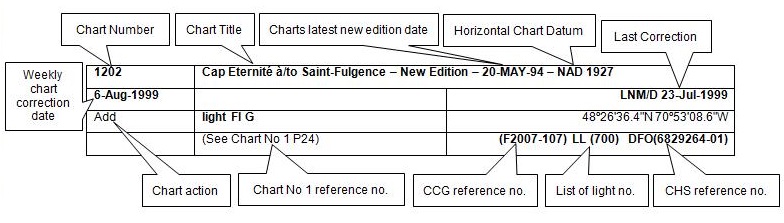
The last correction number is identified with the LNM/D or Last Notice to Mariners Number / Date.
NOTICES TO MARINERS WEBSITE – MONTHLY EDITIONS, CHART CORRECTIONS, AND CHART PATCHES
The Notices to Mariners website allows users to access the monthly publications,
chart corrections, and chart patches.
Users can subscribe for free to the email notification service
to receive notifications when charts of interest are updated, including their patches, as well as when a new monthly edition becomes available online.
ADVISORY NOTICES TO SHIPPING (BROADCAST AND WRITTEN)
The Canadian Coast Guard is implementing a number of changes to the aids to navigation system in Canada.
These changes are advertised as Notices to Shipping (Broadcast and Written) by the Canadian Coast Guard, and are then followed up with Notices to Mariners, then charts are updated by hand correction, reprints or new editions.
Mariners are advised that all relevant Written Notices to Shipping should be kept until superseded by Notices to Mariners or through revised charts issued by the Canadian Hydrographic Service (CHS).
Written Notices to Shipping are available on the Canadian Coast Guard website at: www.ccg-gcc.gc.ca/eng/CCG/NOTSHIP.
The Canadian Hydrographic Service is reviewing the impact of these changes with the Canadian Coast Guard and together are preparing an action plan on the issuing of chart revisions.
For further information, contact your local Regional Notices to Shipping (NOTSHIP) issuing authorities.
Newfoundland
* Port aux Basques MCTS Centre
Canadian Coast Guard
49 Stadium Rd.
P.O. Box 99
Port aux Basques, NL A0M 1C0
Telephone: (709) 695-2168 or 1-800-563-9089
Facsimile: (709) 695-7784
Email: notshippax@dfo-mpo.gc.ca
Website: http://www.ccg-gcc.gc.ca/eng/CCG/Notship#nfld
Central & Arctic
* Prescott MCTS Centre
Canadian Coast Guard
401 King Street West
P.O. Box 1000
Prescott, ON K0E 1T0
“C” Series NOTSHIPs
Telephone: (613) 925-0666
Facsimile: (613) 925-4519
Email: CA.XCA-NotshipDesk@dfo-mpo.gc.ca
Website: http://www.ccg-gcc.gc.ca/eng/CCG/Notship-Home
Maritimes
* Sydney MCTS Centre
Canadian Coast Guard
1190 Westmount Road
Sydney, NS B1R 2J6
Telephone: (902) 564-7751 or 1-800-686-8676
Facsimile: (902) 564-7662
Email: notshipssyd@mar.dfo-mpo.gc.ca
Website: http://www.ccg-gcc.gc.ca/eng/CCG/Notship#maritime
Québec
* Les Escoumins MCTS Centre
Canadian Coast Guard
35, rue Otis
Les Escoumins, QC G0T 1K0
Telephone: (418) 233-2308
Facsimile: (418) 233-3299
Email: opsavis@dfo-mpo.gc.ca
Website: www.marinfo.gc.ca/en/avisecrits/index.asp
* Iqaluit MCTS Centre
Operational from approximately mid-May until late December.
Canadian Coast Guard
P.O. Box 189
Iqaluit, NU X0A 0H0
“A” Series NOTSHIPs
Telephone: (867) 979-5269
Facsimile: (867) 979-4264
Email: IqaNordreg@innav.gc.ca
Website: http://www.ccg-gcc.gc.ca/eng/CCG/Notship-Home
“H” Series NOTSHIPs
Telephone: (867) 979-0310
Facsimile: (867) 979-4264
Email: Iqamck01@innav.gc.ca
Website: http://www.ccg-gcc.gc.ca/eng/CCG/Notship-Home
* Service available in English and French.
Index
NUMERICAL INDEX OF CANADIAN CHARTS AFFECTED
| 1230 | 4015 | 4386 | 4846 |
| 1236 | 4016 | 4429 | 4865 |
| 1320 | 4047 | 4432 | 5047 |
| 1430 | 4117 | 4587 | 6242 |
| 4000 | 4201 | 4639 | 8010 |
| 4001 | 4236 | 4817 | |
| 4002 | 4237 | 4824 | |
| 4006 | 4320 | 4845 |
SECTION 1 - GENERAL AND SAFETY INFORMATION
CANADIAN HYDROGRAPHIC SERVICE – ANNOUNCEMENT REGARDING CHS CHART PATCHES
Colour Web Patches are free to the mariner, and given the quality of many printers, should reproduce well. They will be available in real time all around the world.
CHS welcomes your feedback on this service at chsinfo@dfo-mpo.gc.ca
CANADIAN HYDROGRAPHIC SERVICE – CUMULATIVE CHART CORRECTIONS
The cumulative chart corrections published in
Notices to Mariners can now be accessed
at
https://www.notmar.gc.ca/corrections-en.php
CANADIAN HYDROGRAPHIC SERVICE – CURRENT CHART EDITION DATES
CHART
EDITIONS
The three terms
described below are used to indicate the publication status
of Canadian charts.
NEW CHART -
"NEWCHT"
The first
publication of a Canadian chart embracing an area not
previously charted to the scale shown, or embracing an area
different from any existing Canadian chart.
NEW EDITION -
"NEWEDT"
A new issue of
an existing chart containing amendments essential to
navigation in addition to those issued in Notices
to Mariners and making existing editions
obsolete.
REPRINTS
A new
issue of the current edition of a chart incorporating no
amendments of navigational significance other than those
previously promulgated in Notices to
Mariners. It may also contain amendments from
other sources provided they are not essential to navigation.
Previous printings of the current edition remain in
force.
The current chart edition dates can be accessed at www.chs-shc.gc.ca/charts-cartes/paper-papier/index-eng.asp
CANADIAN HYDROGRAPHIC SERVICE – PRINT ON DEMAND CHARTS - CARE AND USE
Background
By providing nautical charts to the public, the goal of the Canadian Hydrographic Service (CHS) is to provide services for safe navigation in a fiscally responsible manner. As a result, CHS continues to expand its portfolio of nautical paper charts that are printed using Print On Demand (POD) technology. These charts are easily recognized by their whiter paper and the coloured logo of the Canadian Hydrographic Service. This new technology enables CHS to print charts in a more efficient manner, while enhancing chart content through being able to quickly add new and important information. POD technology provides customers with up-to-date charts without the historical hand-drawn corrections or glued-on patches. Additionally, this technology eliminates out-of-stock situations which arise with the traditional printing and warehousing methods. In the event of a national emergency, CHS can respond to the appropriate authorities with the best available information very quickly.
Care of Your POD Chart
CHS encourages its customers to handle the POD charts more carefully than the traditional lithographic charts. When plotting information on POD charts, use HB pencils and apply limited pressure. Testing has suggested that an Indian gum eraser is more effective than alternatives when used on the product. This eraser is also suitable for charts printed using lithographic processes.
CANADIAN HYDROGRAPHIC SERVICE, TRANSPORT CANADA – NAVIGATION SAFETY - ECDIS
Mariners are advised that ECDIS may not display some isolated shoal depths when operating in "base or standard display" mode. Route planning and monitoring alarms for these shoal depths may not always be activated. To ensure safe navigation and to confirm that a planned route is clear of such dangers, mariners should visually inspect the planned route and any deviations from it using ECDIS configured to display "all data". The automated voyage planning check function should not be solely relied upon.
TRANSPORT CANADA – RESTRICTED SPEED AREA - ST. CLAIR AND DETROIT RIVERS
Since November 14, 2012, the restricted speed area currently in place as per the St. Clair and Detroit River Navigation Safety Regulations between the Detroit River light and Peche Island light is reduced in size by relocating the southern point of the restricted speed area from its current location at the Detroit River light to a new location at Bar Point light D33. (This notice refers to the previous one published in November 2012 with number *1103.)
CANADIAN HYDROGRAPHIC SERVICE – MODIFICATION TO CATALOGUE 2: PACIFIC COAST/CÔTE PACIFIQUE
The Canadian Hydrographic Service has been recently
informed that there is an error in the following chart
catalogue:
Catalogue 2:
Pacific Coast/Côte pacifique
Affix patch to Catalogue 2: Pacific Coast/Côte
pacifique provided in Section 1 of this monthly
edition.
https://www.notmar.gc.ca/publications/monthly-mensuel/images/ed072017-part1-catalogue2-patch.pdf
CANADIAN HYDROGRAPHIC SERVICE – MODIFICATIONS TO THE 2018 CANADIAN TIDE AND CURRENT TABLES VOLUME 3 – ST. LAWRENCE RIVER AND SAGUENAY FJORD
The Canadian Hydrographic Service of the Quebec Region identified information missing in the 2018 Canadian Tide and Current Tables Volume 3 - St. Lawrence River and Saguenay Fjord, page 67.
Replace the part of Table 3 with the patch provided
in Section 1 of this monthly
edition.
https://www.notmar.gc.ca/publications/monthly-mensuel/images/ed012018-part1-tidal-information-vol3-p67-patch.pdf
CANADIAN HYDROGRAPHIC SERVICE – NEW LOCATION TO DOWNLOAD PATCHES
The Canadian Hydrographic Service has moved patch downloads from http://www.chs-shc.gc.ca/patches/ to ftp://ftp.dfo-mpo.gc.ca/patches/. The PDF versions of the monthly editions of Notices to Mariners prior to July 2017 are published with the previous location to download patches, while the HTML versions have the updated hyperlinks to the new location. These changes have also been applied to the “Search Chart Corrections” service on the Notices to Mariners website (https://www.notmar.gc.ca/corrections-en.php).
ERRATUM: SECTION 2 – CHART CORRECTIONS - CHART 4386 - CORRECTION DATE: 30-MAR-2018
AMEND
|
4386 - Head Harbour - New Edition - 16-JUL-2004 - NAD 1983 |
|||
|---|---|---|---|
|
30-MAR-2018 |
LNM/D. 30-JUN-2017 |
||
|
Add |
depth of 4 metres, 2 decimetres |
44°39′42.1″N 063°54′36.6″W |
|
|
(See Chart No. 1, I10) |
|||
|
This notice affects Electronic Navigational Chart: CA476196 |
|||
|
DFO(6307923-04) |
|||
TO READ
|
4386 - Head Harbour - New Edition - 16-JUL-2004 - NAD 1983 |
|||
|---|---|---|---|
|
30-MAR-2018 |
LNM/D. 30-JUN-2017 |
||
|
Add |
depth of 4 metres, 2 decimetres |
44°39′42.1″N 063°54′36.6″W |
|
|
(See Chart No. 1, I10) |
|||
|
This notice affects Electronic Navigational Chart: CA476195, CA476196 |
|||
|
DFO(6307923-04) |
|||
ADD
|
4386 - St. Margaret's Bay - New Edition - 16-JUL-2004 - NAD 1983 |
|||
|---|---|---|---|
|
30-MAR-2018 |
LNM/D. 30-JUN-2017 |
||
|
Add |
depth of 4 metres, 2 decimetres |
44°39′42.1″N 063°54′36.6″W |
|
|
(See Chart No. 1, I10) |
|||
|
This notice affects Electronic Navigational Chart: CA476195, CA476196 |
|||
|
DFO(6307923-04) |
|||
*401 CANADIAN HYDROGRAPHIC SERVICE – ELECTRONIC NAVIGATIONAL CHARTS
|
S-57 ENC NUMBER |
CHART TITLE |
|---|---|
|
NEW PRODUCTS |
|
|
CA276322 |
Cape Harrison to/à Nunaksaluk Island |
|
CA470613 |
Caamaño to/à Nepean Sound |
|
CA479249 |
Baie de Bonne-Espérance à/to Île Mistanoque |
|
CA573487 |
Ulukhaktok |
|
CA576086 |
St. George's Public Wharf / Quai public |
|
CA576191 |
Little Port |
|
CA576192 |
The Narrows |
|
CA579250 |
Baie Chevalier |
|
CA579251 |
Passe Champlain |
|
CA579252 |
Vieux-Fort |
*402 CANADIAN HYDROGRAPHIC SERVICE – RASTER DIGITAL CHARTS (BSB V3)
|
CHARTS |
MAIN TITLE |
SCALE |
PUBLISHED |
|---|---|---|---|
|
New Charts |
|||
|
RM-3980 |
Laredo Sound |
1:40 000 |
13-JAN-2017 |
|
Charts Permanently Withdrawn |
|||
|
RM-4470 |
Blanc Sablon à/to Middle Bay |
||
|
RM-4471 |
Baie au Saumon à/to Baie des Homards |
||
*403 TRANSPORT CANADA – SHIP SAFETY BULLETIN #04/2018
This is to notify you that a new Ship Safety Bulletin has recently been posted to the Transport Canada website at www.tc.gc.ca/ssb-bsn/.
To go online to view or download this bulletin, please click on the link below:
SSB#04/2018
- Marine Diesel Engines In Small Canadian
Vessels
RDIMS#13634117
Sign yourself up for e-Bulletin to receive an e-mail notice each time a new Ship Safety Bulletin is published on our Website.
Contact us at: marinesafety-securitemaritime@tc.gc.ca or 1-855-859-3123 (Toll Free).
*404 CANADIAN COAST GUARD PUBLICATION – RADIO AIDS TO MARINE NAVIGATION (ATLANTIC, ST. LAWRENCE, GREAT LAKES, LAKE WINNIPEG, ARCTIC AND PACIFIC) – 2018
The 2018 Edition of the Radio Aids to Marine Navigation (Atlantic, St. Lawrence, Great Lakes, Lake Winnipeg, Arctic and Pacific) is now available for download, free of charge, on the Marine Communications and Traffic Services (MCTS) website: http://www.ccg-gcc.gc.ca/Marine-Communications/Home. Paper copies of this publication are no longer sold.
Amendments to this publication are advertised by radio broadcast (Notices to Shipping) and/or in Section 3 of the monthly editions of Notices to Mariners (https://www.notmar.gc.ca/monthly-mensuel-en.php). The 2018 edition has been revised up to April 27th, 2018 and supersedes the 2017 edition.
*405 SAGUENAY–ST. LAWRENCE MARINE PARK AND SURROUNDING WATERS – WHALE PROTECTION
The waters in and around the Saguenay–St. Lawrence Marine Park are well known for the resident endangered beluga population and the wide diversity of whales that migrate there to feed, particularly between April and November.
REGULATORY PROTECTION MEASURES
All whale species that are found in the St. Lawrence are protected under the Marine Mammal Regulations, pursuant to the Fisheries Act. Within the boundaries of the Marine Park, specific measures are set out in the Marine Activities in the Saguenay–St. Lawrence Marine Park Regulations, pursuant to the Act Establishing the Saguenay–St. Lawrence Marine Park. Any collision with a marine mammal within the Marine Park must immediately be reported to a park warden at 1-866-508-9888. For collisions that occur outside the Marine Park or for any situation involving a marine mammal that is dead or in trouble, contact the emergency network at 1-877-722-5346 or on channel 16.
For more information on the Saguenay–St. Lawrence Marine Park, see notice 5C of the Notices to Mariners Annual Edition 2018.
VOLUNTARY PROTECTION MEASURES
Provisional measures in effect from May 1st to October 31st, 2018. See map at the end of this notice.
These measures apply to merchant vessels and cruise ships between Pointe à Boisvert and Cap de la Tête au Chien to prevent collisions with whales. These measures should only be taken when they will not jeopardize navigational safety.
Caution area (yellow area): To reduce the risk of collisions with whales that can be present anywhere in this area, heightened vigilance of navigators is critical. Posting a lookout is recommended in order to increase the chances of seeing the whales and thus taking necessary measures to avoid them. If bypassing the whales is not possible, slow down and wait for the animals to move away to a distance greater than 400 meters (0.215 nautical miles) before resuming original speed. It is more difficult to see the animals at night, therefore increased caution is recommended.
Slow down to 10 knots or less area (red area): To reduce the risk of collisions with whales in this feeding area, it is recommended that vessels slow down to a maximum speed through the water of 10 knots and post a lookout. It is further recommended to remain in the Laurentian Channel to the north of Île Rouge to minimize the impact of noise in a sensitive area south of this island, which is highly frequented by herds of beluga whales composed of females and young.
Area to be avoided (hatched red area): To reduce noise and the risk of collisions with whales, vessels should avoid transiting through this area which is highly frequented by blue whales, an endangered species. If the area cannot be avoided, slow down to a speed through the water of 10 knots or less.

*406 GULF OF ST. LAWRENCE - PROTECTION OF THE NORTH ATLANTIC RIGHT WHALE
Due to the changing migratory habits of the North Atlantic Right whale and their increased presence in the Gulf of St. Lawrence, the Government of Canada has put in place seasonal speed restrictions in specified areas. These restrictions are a combination of static zone and dynamic speed reduction sectors. (See map below.)
These measures are in effect from April 28 to November 15, 2018. These dates are subject to change dependent on North Atlantic Right whale presence. Once the mandatory speed restriction has been lifted, vessels are asked to voluntarily reduce their speed to not exceed 10.0 knots over the ground in the presence of North Atlantic Right whales only if maritime conditions permit safe operation of their vessel at that speed.
Static zone coordinates:47° 10'N 062°
00'W; 47° 10'N 065° 00'W; 50° 20'N 065° 00'W; 50° 20'N 063°
00'W;
49° 43’N 063° 00’W and
49° 04’N 062° 00’W
Within the static zone, with the exclusion of the dynamic sector corridor, vessels 20 m or more in length are required to operate at a speed not exceeding 10.0 knots over the ground during the above specified dates.
Dynamic sector coordinates:
Sector A) 49° 41’N 065° 00’W;
49° 20’N 065° 00’W;
49° 11’N 064°
00’W; 49° 22’N
064° 00’W;
Sector
B) 49° 22’N 064° 00’W;
49° 11’N 064°
00’W; 48° 48’N
063° 00’W; 49°
00’N 063° 00’W;
Sector
C) 49° 00’N 063° 00’W;
48° 48’N 063°
00’W; 48° 24’N
062° 00’W; 48°
35’N 062° 00’W; and
Sector
D) 50° 06’N 064° 00’W;
50° 00’N 064°
00’W; 49° 56’N
063° 00’W; 50°
03’N 063° 00’W.
Within the static zone, there are four dynamic sectors: A, B, C and D. Within these sectors, vessels may proceed at a safe operational speed when the Government of Canada has determined that whales do not appear to be present. When North Atlantic Right whale presence has been determined inside a dynamic sector, vessels 20 m or more in length will be notified through a Notice to Shipping (NOTSHIP) and are required to reduce their speed to not exceed 10.0 knots over the ground within that sector.

Speed restrictions within the dynamic sectors (A, B, C and D) will be in effect for 15 days, from the date of issuance, and can be extended in the event of continued whale presence. The establishment of speed reduction zones and sectors will be announced through NOTSHIPs.
NOTSHIP Broadcasts
The Canadian Coast Guard (CCG) continues to promulgate valid NOTSHIPs via radio broadcasts over various terrestrial systems and also online at http://www.ccg-gcc.gc.ca/navigating-hub. Mariners shall ensure that they have correct and up-to-date information concerning the protection of the North Atlantic Right whales as contained in all applicable Notices to Mariners (NOTMARs) and NOTSHIPs.
Aids to Navigation
In addition, CCG is testing the use of virtual AIS aids
to navigation (AIS AtoN), NOTMAR 819(T)/2016 refers, which
will notify a mariner of a dynamic sector that is subject to
a speed reduction. Each dynamic sector will be delimited by
four virtual AIS AtoN which could be displayed on ship’s
navigation equipment such as: ECDIS, ECS, RADAR, Minimum
Keyboard Display, and Electronic Nautical Charts. The virtual
AIS AtoN will be broadcasted only when speed reduction is in
effect in one or more sectors. The mariner is required to
select the virtual AIS AtoN symbol to view a message as such:
“SectA1 Spd Lim 10 kt.” This message refers to a speed
reduction in effect for a specific sector. As this system
continues to be in the testing phase, it is not the primary
means of communicating with the mariner.
Compliance and Enforcement
Failure to comply with mandatory speed restrictions could lead to enforcement action and subject to fines ranging from $6,000 Cdn to $25,000 Cdn. If vessels appear to have violated the speed restriction, Transport Canada Marine Safety Inspectors will review all information provided through AIS and seek information from the master.
Exemptions to the speed restrictions will not be granted in advance; however, factors such navigation to ensure vessel safety, weather conditions, and responding to emergencies, will be reviewed and considered.
Reporting of Whale Sightings
Mariners are requested to report all observations of entangled, dead, or injured whales to the nearest CCG Marine Communication and Traffic Services Centre; or as follows:
•For the southern part of the Gulf of St. Lawrence:
–Marine Animal Response Society at 1-866-567-6277
•For Newfoundland and Labrador:
–Whale Release and Strandings at 1-888-895-3003
•For the Québec sector:
–Marine Mammal emergencies at 1-877-722-5346.
Sightings of live, free-swimming whales should be reported by phone to 1-902-440-8611 or 1-844-800-8568 or by email: XMARWHALESIGHTINGS@DFO-MPO.GC.CA
*407 CANADIAN COAST GUARD - LIST OF CHARTS AND REFERENCE CHARTS (SECTION 1) AFFECTED BY TEMPORARY AND PRELIMINARY NOTICES
IN EFFECT APRIL 27th, 2018
(REVISED AND PROMULGATED QUARTERLY)
|
1430 |
409(P)/18 |
4244 |
1006(T)/14 |
|
1432 |
107(P)/17 |
4266 |
309(P)/18 |
|
2017 |
909(T)/14 |
4302 |
906(P)/17 907(P)/17 |
|
2044 |
1005(T)/15 |
4307 |
908(P)/17 |
|
2060 |
814(T)/16 |
4377 |
405(P)/13 |
|
2067 |
1218(T)/16 |
4406 |
207(P)/18 |
|
2077 |
1011(T)/16 |
4419 |
1204(P)/17 |
|
2085 |
1205(T)/17 112(T)/18 211(T)/18 |
4426 |
310(P)/18 |
|
2086 |
1219(T)/16 |
4443 |
1106(P)/17 1107(P)/17 |
|
2123 |
309(T)/17 |
4459 |
208(P)/18 |
|
2181 |
108(T)/17 |
4460 |
311(P)/18 312(P)/18 |
|
2202 |
109(P)/17 |
4466 |
313(P)/18 314(P)/18 |
|
2235 |
818(T)/16 |
4491 |
1007(P)/17 |
|
2315 |
515(T)/16 |
4523 |
209(P)/18 |
|
3479 |
617(P)/17 |
4587 |
413(P)/18 |
|
3513 |
410(P)/18 |
4591 |
210(P)/18 |
|
3540 |
411(P)/18 |
4642 |
315(P)/18 |
|
3624 |
1116(P)/16 |
4644 |
1106(T)/15 |
|
3646 |
618(P)/17 1010(P)/17 |
4845 |
414(P)/18 |
|
3671 |
620(P)/17 |
4865 |
415(P)/18 |
|
3675 |
1118(P)/16 |
4909 |
613(P)/12 |
|
3676 |
1119(P)/16 |
4911 |
811(P)/12 510(P)/15 |
|
3679 |
1121(P)/16 |
4913 |
518(P)/16 |
|
3681 |
1122(P)/16 |
5047 |
416(P)/18 |
|
3686 |
1123(P)/16 |
6022 |
1206(T)/17 |
|
3890 |
1108(P)/17 |
6218 |
204(T)/16 |
|
4010 |
608(P)/17 |
6242 |
113(T)/18 417(P)/18 418(P)/18 |
|
4116 |
205(P)/18 |
6267 |
114(T)/18 |
|
4117 |
206(P)/18 |
6287 |
113(T)/17 |
|
4236 |
610(P)/15 412(P)/18 |
14853 (U.S.) |
808(P)/17 |
*408 LAC SAINT-LOUIS – PRIVATE UNLIT BUOYS REPOSITIONED
Reference Chart: 1430
The following private unlit buoys have been repositioned to the following coordinates:
| AH27 | (LL 5021.51) | 45º 19’ 36.2’’N 073º 51’ 04.9’’W |
| AH28 | (LL 5021.52) | 45º 19’ 36.3’’N 073º 51’ 05.6’’W |
(Q2018-007, 008)
*409(P) LAC SAINT-LOUIS – RANGE TO BE AMENDED
Reference: Notice 809(P)/15 is cancelled.
Reference Chart: 1430
The Canadian Coast Guard proposes to permanently replace the following aids to navigation:
To discontinue the Dixie range lights (LL 1201-1202), which operates at night only, and replace it by a sector light located at position 45° 25’ 16.04’’N 073° 44’ 45.02’’W. This new sector light would have a nominal range of 5 nautical miles.
The arcs of visibility (true bearing) would be the
following:
Red
sector:from 107° to 52°.
White
sector: from 52° to 50°.
Green
sector: from 50° to 264°.
This change will be effective starting summer 2018.
For more information:
Superintendent, Lise
Richard
Aids to Navigation & Waterways,
Central & Arctic
Region
Canadian Coast
Guard
101 boulevard
Champlain
Quebec, QC G1K
7Y7
Telephone: (418)
648-7450
Email:
lise.richard@dfo-mpo.gc.ca
*412(P) TAYLORS HEAD TO / À SHUT-IN ISLAND – SECTOR LIGHT TO BE DISCONTINUED
Reference Chart: 4236
The Canadian Coast Guard proposes to permanently discontinue the following aid to navigation:
| Spry Bay Sector | (LL 591) | (44° 49’ 21.5’’N 062° 35’ 54.3’’W) |
Comments on this action are solicited from mariners and other interested parties by July 27th, 2018, three months following the initial publication date of April 27th, 2018. Comments should be directed to the following:
Superintendent, Renee
Pope
Aids to Navigation and
Waterways
Canadian Coast Guard
P.O. Box 5667
St. John’s, NL A1C 5X1
Telephone: (709)
772-2800
Email:
renee.pope@dfo-mpo.gc.ca
Any objections raised must state the facts on which they are based and should include supporting information on safety, commerce and public benefit.
(F2018-008)
*413(P) MORTIER BAY – NOTICE OF PROPOSED CHANGES
Reference Chart: 4587
The Canadian Coast Guard proposes to permanently change the following aids to navigation:
|
LL # |
Name of Aid |
Position |
Proposed Changes |
|---|---|---|---|
|
64.81 |
Pick Ledge
|
47° 08’
10.1”N |
Remove sound
(bell). |
|
64.82 |
Blow Me Down
|
47° 07’
42.1”N |
Remove sound
(bell). |
|
64.83 |
Thomas Rocks
|
47° 07’
40.0”N |
Remove sound
(bell). |
|
64.84 |
Mortier Bay
|
47° 07’
06.0”N |
Remove sound
(whistle). |
Comments on this action are solicited from mariners and other interested parties by July 27th, 2018, three months following the initial publication date of April 27th, 2018. Comments should be directed to the following:
Superintendent, Renee
Pope
Aids to Navigation and
Waterways
Canadian Coast Guard
P.O. Box 5667
St. John’s, NL A1C 5X1
Telephone: (709)
772-2800
Email:
renee.pope@dfo-mpo.gc.ca
Any objections raised must state the facts on which they are based and should include supporting information on safety, commerce and public benefit.
(N2018-019)
*414(P) RENEWS HARBOUR TO/À MOTION BAY – LIGHT BUOY TO BE DISCONTINUED
Reference Chart: 4845
The Canadian Coast Guard proposes to permanently discontinue the following aid to navigation:
| Aquaforte Harbour Shoal light buoy MA2 | (LL 509.5) | (47° 00’ 21.8’’N 052° 57’ 22.8’’W) |
Comments on this action are solicited from mariners and other interested parties by July 27th, 2018, three months following the initial publication date of April 27th, 2018. Comments should be directed to the following:
Superintendent, Renee
Pope
Aids to Navigation and
Waterways
Canadian Coast Guard
P.O. Box 5667
St. John’s, NL A1C 5X1
Telephone: (709)
772-2800
Email:
renee.pope@dfo-mpo.gc.ca
Any objections raised must state the facts on which they are based and should include supporting information on safety, commerce and public benefit.
(N2018-017)
*415(P) APPROACHES TO / APPROCHES À LEWISPORTE AND / ET LOON BAY – NOTICE OF PROPOSED CHANGES
Reference Chart: 4865
The Canadian Coast Guard proposes to permanently change the following aid to navigation:
| Jobs Island light buoy DLW2 | (LL 352.4) | (49° 17’ 54.2”N 055° 00’ 22.4”W): |
-Change position to 49°17.797’N 055°00.384’W.
-Change from starboard to South cardinal.
-Change flash characteristics from Red, Fl 0.5s Ec 3.5s, to White, (Q(6) + LFl) 15s.
-Change aid ID from DLW2 to DLW.
Comments on this action are solicited from mariners and other interested parties by July 27th, 2018, three months following the initial publication date of April 27th, 2018. Comments should be directed to the following:
Superintendent, Renee
Pope
Aids to Navigation and
Waterways
Canadian Coast Guard
P.O. Box 5667
St. John’s, NL A1C 5X1
Telephone: (709)
772-2800
Email:
renee.pope@dfo-mpo.gc.ca
Any objections raised must state the facts on which they are based and should include supporting information on safety, commerce and public benefit.
(N2018-018)
*416(P) WINSOR HARBOUR ISLAND TO / AUX KIKKERTAKSOAK ISLANDS – LIGHT TO BE DISCONTINUED
Reference Chart: 5047
The Canadian Coast Guard proposes to permanently discontinue the following aid to navigation:
| Bluff Point | (LL 320.6) | (55° 15’ 51.7’’N 060° 02’ 02.0’’W) |
Comments on this action are solicited from mariners and other interested parties by July 27th, 2018, three months following the initial publication date of April 27th, 2018. Comments should be directed to the following:
Superintendent, Renee
Pope
Aids to Navigation and
Waterways
Canadian Coast Guard
P.O. Box 5667
St. John’s, NL A1C 5X1
Telephone: (709)
772-2800
Email:
renee.pope@dfo-mpo.gc.ca
Any objections raised must state the facts on which they are based and should include supporting information on safety, commerce and public benefit.
(N2018-014)
*417(P) WINNIPEG TO/AU LAKE WINNIPEG/LAC WINNIPEG – LIGHTS TO BE DISCONTINUED
Reference Chart: 6242
The Canadian Coast Guard proposes to permanently discontinue the following aids to navigation:
| Red River range front | (LL 1562) | (50° 23’ 41.6’’N 096° 48’ 38.0’’W) |
| Red River range rear | (LL 1563) | (163°05' 602.7 m from front.) |
| Red River Mouth West Breakwater | (LL 1563.3) | (50° 24’ 04.3’’N 096° 48’ 51.3’’W) |
| East Breakwall RACON | (LL 9759.5) | (50° 24’ 05.0’’N 096° 48’ 45.7’’W) |
Comments on this action are solicited from mariners and other interested parties by July 27th, 2018, three months following the initial publication date of April 27th, 2018. Comments should be directed to the following:
A/Superintendent, Glenna
Evans
Aids to Navigation & Waterways, Western
Region
Canadian Coast Guard
25 Huron Street
Victoria, BC V8V 4V9
Telephone: (250)
480-2602
Fax: (250)
480-2702
Email: glenna.evans@dfo-mpo.gc.ca
Any objections raised must state the facts on which they are based and should include supporting information on safety, commerce and public benefit.
(A2018-009)
*418(P) WINNIPEG TO/AU LAKE WINNIPEG/LAC WINNIPEG – UNLIT BUOYS PERMANENTLY DISCONTINUED
Reference Chart: 6242
The Canadian Coast Guard has permanently discontinued the following aids to navigation:
| Red River Mouth spar buoy X9 | (LL 9758) | 50º 24’ 47.4’’N 096º 49’ 05.4’’W (NAD83) |
| Red River Mouth buoy X17A | (LL 9764.4) | 50º 23’ 48.2’’N 096º 48’ 40.5’’W (NAD83) |
Comments on this action are solicited from mariners and other interested parties by July 27th, 2018, three months following the initial publication date of April 27th, 2018. Comments should be directed to the following:
A/Superintendent, Glenna
Evans
Aids to Navigation & Waterways, Western
Region
Canadian Coast Guard
25 Huron Street
Victoria, BC V8V 4V9
Telephone: (250)
480-2602
Fax: (250)
480-2702
Email: glenna.evans@dfo-mpo.gc.ca
Any objections raised must state the facts on which they are based and should include supporting information on safety, commerce and public benefit.
(A2018-008, 010)
SECTION 2 - CHART CORRECTIONS
1230 - Les Méchins - New Edition - 19-FEB-2010 - NAD 1983
| 27-APR-2018 | LNM/D. 23-FEB-2018 | ||
| Add |
drying height of 0 metres 8 decimetres (See Chart No. 1, I15) This notice affects Electronic Navigational Chart: CA579056 |
49°00′19.3″N 066°58′48.2″W | |
| DFO(6409777-01) | |||
| Add |
depth of 1 metre 5 decimetres (See Chart No. 1, I10) This notice affects Electronic Navigational Chart: CA579056 |
49°00′20.3″N 066°58′48.0″W | |
| DFO(6409777-02) | |||
| Delete |
depth of 3 metres 2 decimetres (See Chart No. 1, I10) This notice affects Electronic Navigational Chart: CA579056 |
49°00′23.3″N 066°58′44.4″W | |
| DFO(6409777-03) | |||
| Add |
depth of 2 metres 7 decimetres (See Chart No. 1, I10) This notice affects Electronic Navigational Chart: CA579056 |
49°00′23.0″N 066°58′44.2″W | |
| DFO(6409777-04) | |||
| Add |
depth of 4 metres 2 decimetres (See Chart No. 1, I10) This notice affects Electronic Navigational Chart: CA579056 |
49°00′23.4″N 066°58′41.1″W | |
| DFO(6409777-05) |
1236 - Godbout - New Edition - 26-OCT-2012 - NAD 1983
| 06-APR-2018 | LNM/D. 02-MAR-2018 | ||
| Delete |
depth of 3 metres 7 decimetres (See Chart No. 1, I10) This notice affects Electronic Navigational Chart: CA579038 |
49°19′26.6″N 067°35′29.2″W | |
| DFO(6409778-07) | |||
| Add |
depth of 1 metre 0 decimetres (See Chart No. 1, I10) This notice affects Electronic Navigational Chart: CA579038 |
49°19′26.7″N 067°35′29.3″W | |
| DFO(6409778-08) |
1236 - Pointe des Monts aux/to Escoumins - New Edition - 26-OCT-2012 - NAD 1983
| 06-APR-2018 | LNM/D. 02-MAR-2018 | ||
| Add |
depth of 6 metres 4 decimetres (See Chart No. 1, I10) This notice affects Electronic Navigational Chart: CA279037 |
49°17′56.1″N 067°39′44.6″W | |
| DFO(6409778-01) | |||
| Delete |
depth of 3 metres 2 decimetres (See Chart No. 1, I10) This notice affects Electronic Navigational Chart: CA279037 |
49°18′14.9″N 067°39′06.2″W | |
| DFO(6409778-02) | |||
| Add |
depth of 2 metres 9 decimetres (See Chart No. 1, I10) This notice affects Electronic Navigational Chart: CA279037 |
49°18′14.6″N 067°39′00.8″W | |
| DFO(6409778-03) | |||
| Add |
depth of 7 metres 0 decimetres (See Chart No. 1, I10) This notice affects Electronic Navigational Chart: CA279037 |
49°18′04.4″N 067°38′03.0″W | |
| DFO(6409778-04) | |||
| Delete |
depth of 3 metres 2 decimetres (See Chart No. 1, I10) This notice affects Electronic Navigational Chart: CA279037 |
49°18′16.4″N 067°35′57.9″W | |
| DFO(6409778-05) | |||
| Add |
drying height of 0 metres 7 decimetres (See Chart No. 1, I15) This notice affects Electronic Navigational Chart: CA279037 |
49°18′23.7″N 067°35′54.5″W | |
| DFO(6409778-06) |
1320 - Port de Gros-Cacouna - New Chart - 26-AUG-2011 - NAD 1983
| 13-APR-2018 | LNM/D. 12-JAN-2018 | ||
| Delete |
depth of 7 metres 8 decimetres (See Chart No. 1, I10) This notice affects Electronic Navigational Chart: CA579234 |
47°55′47.4″N 069°31′10.0″W | |
| DFO(6409783-01) | |||
| Delete |
depth of 7 metres 3 decimetres (See Chart No. 1, I10) This notice affects Electronic Navigational Chart: CA579234 |
47°55′42.6″N 069°31′02.5″W | |
| DFO(6409783-02) | |||
| Add |
depth of 7 metres 0 decimetres (See Chart No. 1, I10) This notice affects Electronic Navigational Chart: CA579234 |
47°55′42.9″N 069°31′02.4″W | |
| DFO(6409783-03) | |||
| Delete |
depth of 7 metres 6 decimetres (See Chart No. 1, I10) This notice affects Electronic Navigational Chart: CA579234 |
47°55′39.6″N 069°30′54.3″W | |
| DFO(6409783-04) | |||
| Add |
depth of 7 metres 1 decimetre (See Chart No. 1, I10) This notice affects Electronic Navigational Chart: CA579234 |
47°55′39.5″N 069°30′54.9″W | |
| DFO(6409783-05) | |||
| Delete |
depth of 7 metres 5 decimetres (See Chart No. 1, I10) This notice affects Electronic Navigational Chart: CA579234 |
47°55′55.1″N 069°30′56.6″W | |
| DFO(6409783-06) | |||
| Delete |
depth of 7 metres 2 decimetres (See Chart No. 1, I10) This notice affects Electronic Navigational Chart: CA579234 |
47°55′54.0″N 069°30′52.6″W | |
| DFO(6409783-07) | |||
| Add |
depth of 6 metres 9 decimetres (See Chart No. 1, I10) This notice affects Electronic Navigational Chart: CA579234 |
47°55′52.8″N 069°30′53.5″W | |
| DFO(6409783-08) |
4000 - Gulf of Maine to/à Baffin Bay / Baie de Baffin - New Edition - 25-JUL-2003 - NAD 1983
| 06-APR-2018 | LNM/D. 01-DEC-2017 | ||
| Delete |
yellow ODAS/SADO lighted super-buoy, marked 44140 (See Chart No. 1, Q58) This notice affects Electronic Navigational Chart: CA176030, CA276514 |
42°52′00.0″N 051°28′00.0″W | |
| DFO(6308224-04) |
4001 - Gulf of Maine to Strait of Belle Isle / au Detroit de Belle Isle - New Edition - 01-DEC-1995 - NAD 1983
| 06-APR-2018 | LNM/D. 01-DEC-2017 | ||
| Delete |
yellow ODAS/SADO lighted super-buoy Fl (5) Y, marked
44255 (See Chart No. 1, Q58) This notice affects Electronic Navigational Chart: CA179245, CA276284 |
47°17′00.0″N 057°21′00.0″W | |
| DFO(6308224-01) | |||
| Delete |
yellow ODAS/SADO lighted super-buoy, marked 44251 (See Chart No. 1, Q58) This notice affects Electronic Navigational Chart: CA176030, CA276091, CA376075 |
46°26′30.0″N 053°24′00.0″W | |
| DFO(6308224-02) | |||
| Delete |
yellow ODAS/SADO lighted super-buoy, marked 44138 (See Chart No. 1, Q58) This notice affects Electronic Navigational Chart: CA176030, CA276091 |
44°15′00.0″N 053°38′00.0″W | |
| DFO(6308224-03) | |||
| Delete |
yellow ODAS/SADO lighted super-buoy, marked 44140 (See Chart No. 1, Q58) This notice affects Electronic Navigational Chart: CA176030, CA276514 |
42°52′00.0″N 051°28′00.0″W | |
| DFO(6308224-04) |
4002 - Golfe du Saint-Laurent / Gulf of St. Lawrence - New Edition - 30-OCT-2015 - NAD 1983
| 06-APR-2018 | LNM/D. 23-MAR-2018 | ||
| Delete |
yellow ODAS/SADO lighted super-buoy Fl (5) Y, marked
44255 (See Chart No. 1, Q58) This notice affects Electronic Navigational Chart: CA179245, CA276284 |
47°16′00.0″N 057°21′00.0″W | |
| DFO(6308224-01) |
4006 - Newfoundland and Labrador/Terre-Neuve-et-Labrador to Bermuda / aux Bermudes - New Edition - 08-AUG-2003 - NAD 1983
| 06-APR-2018 | LNM/D. 01-DEC-2017 | ||
| Delete |
yellow ODAS/SADO lighted super-buoy, marked 44251 (See Chart No. 1, Q58) This notice affects Electronic Navigational Chart: CA176030, CA276091, CA376075 |
46°26′30.0″N 053°23′30.0″W | |
| DFO(6308224-02) | |||
| Delete |
yellow ODAS/SADO lighted super-buoy, marked 44138 (See Chart No. 1, Q58) This notice affects Electronic Navigational Chart: CA176030, CA276091 |
44°15′00.0″N 053°38′00.0″W | |
| DFO(6308224-03) |
4015 - Sydney to / à Saint-Pierre - New Edition - 28-MAR-2003 - NAD 1983
| 06-APR-2018 | LNM/D. 02-FEB-2018 | ||
| Delete |
yellow ODAS/SADO lighted super-buoy Fl (5) Y, marked
44255 (See Chart No. 1, Q58) This notice affects Electronic Navigational Chart: CA179245, CA276284 |
47°16′00.0″N 057°21′00.0″W | |
| DFO(6308224-01) |
4016 - Saint-Pierre to / à St. John's - New Edition - 06-JUN-2003 - NAD 1983
| 06-APR-2018 | LNM/D. 02-FEB-2018 | ||
| Delete |
yellow ODAS/SADO lighted super-buoy Fl (5) Y, marked
44251 (See Chart No. 1, Q58) This notice affects Electronic Navigational Chart: CA176030, CA276091, CA376075 |
46°26′30.0″N 053°23′18.0″W | |
| DFO(6308224-02) |
4047 - St. Pierre Bank / Banc de Saint-Pierre to / au Whale Bank / Banc de la Baleine - New Edition - 09-OCT-1998 - NAD 1983
| 06-APR-2018 | LNM/D. 31-MAR-2017 | ||
| Delete |
yellow ODAS/SADO lighted super-buoy Fl (5) Y, marked
44251 (See Chart No. 1, Q58) This notice affects Electronic Navigational Chart: CA176030, CA276091, CA376075 |
46°26′30.0″N 053°23′30.0″W | |
| DFO(6308224-02) | |||
| Delete |
yellow ODAS/SADO lighted super-buoy Fl (5) Y, marked
44138 (See Chart No. 1, Q58) This notice affects Electronic Navigational Chart: CA176030, CA276091 |
44°13′00.0″N 053°36′00.0″W | |
| DFO(6308224-03) |
4117 - Saint John Harbour and Approaches / et les approches - New Edition - 29-MAY-2009 - NAD 1983
| 13-APR-2018 | LNM/D. 19-MAY-2017 | ||
| Add |
light Fl R against red starboard hand spar buoy, marked
JC8 (See Chart No. 1, Q7) This notice affects Electronic Navigational Chart: CA576005 |
45°15′23.6″N 066°02′47.1″W | |
| (F2018006) LL(105.8) DFO(6308251-01) |
4201 - Halifax Harbour: Bedford Basin - New Edition - 25-AUG-2017 - NAD 1983
| 06-APR-2018 | LNM/D. 23-FEB-2018 | ||
| Add |
yellow ODAS/SADO lighted pillar Fl(5)Y 20s (See Chart No. 1, Q58) This notice affects Electronic Navigational Chart: CA576001 |
44°41′26.5″N 063°38′23.5″W | |
| DFO(6308228-01) |
4237 - Approaches to / Approches de Halifax Harbour - New Edition - 02-JUN-2000 - NAD 1983
| 13-APR-2018 | LNM/D. 17-NOV-2017 | ||
| Replace |
depth of 7 metres with depth of 5 metres, 8
decimetres (See Chart No. 1, I10) This notice affects Electronic Navigational Chart: CA476009 |
44°27′27.5″N 063°32′39.5″W | |
| DFO(6307886-01) | |||
| Replace |
depth of 12 metres, 8 decimetres with depth of 9 metres,
3 decimetres (See Chart No. 1, I10) This notice affects Electronic Navigational Chart: CA476009 |
44°27′30.9″N 063°32′45.4″W | |
| DFO(6307886-02) | |||
| Delete |
depth of 7 metres, 3 decimetres (See Chart No. 1, I10) This notice affects Electronic Navigational Chart: CA476009 |
44°27′25.2″N 063°32′54.0″W | |
| DFO(6307886-03) | |||
| Add |
depth of 4 metres, 8 decimetres (See Chart No. 1, I10) This notice affects Electronic Navigational Chart: CA476009 |
44°27′23.1″N 063°32′55.7″W | |
| DFO(6307886-04) | |||
| Delete |
depth of 8 metres, 8 decimetres (See Chart No. 1, I10) This notice affects Electronic Navigational Chart: CA476009 |
44°26′33.0″N 063°31′36.4″W | |
| DFO(6307886-05) | |||
| Replace |
depth of 5 metres, 8 decimetres with depth of 3
metres (See Chart No. 1, I10) This notice affects Electronic Navigational Chart: CA476009 |
44°26′52.4″N 063°32′10.7″W | |
| DFO(6307886-06) | |||
| Replace |
depth of 7 metres, 6 decimetres with depth of 5 metres, 7
decimetres (See Chart No. 1, I10) This notice affects Electronic Navigational Chart: CA476009 |
44°26′43.2″N 063°32′26.2″W | |
| DFO(6307886-07) | |||
| Replace |
depth of 11 metres with depth of 8 metres, 6
decimetres (See Chart No. 1, I10) This notice affects Electronic Navigational Chart: CA476009 |
44°26′43.5″N 063°32′16.9″W | |
| DFO(6307886-08) | |||
| Replace |
depth of 4 metres with depth of 3 metres (See Chart No. 1, I10) This notice affects Electronic Navigational Chart: CA476009 |
44°26′32.3″N 063°31′55.0″W | |
| DFO(6307886-09) | |||
| Replace |
depth of 4 metres with depth of 1 metre, 5
decimetres (See Chart No. 1, I10) This notice affects Electronic Navigational Chart: CA476009 |
44°26′18.7″N 063°32′20.7″W | |
| DFO(6307886-10) | |||
| Replace |
depth of 4 metres, 9 decimetres with depth of 3 metres, 8
decimetres (See Chart No. 1, I10) This notice affects Electronic Navigational Chart: CA476009 |
44°26′12.6″N 063°32′38.9″W | |
| DFO(6307886-11) | |||
| Replace |
depth of 9 metres, 4 decimetres with depth of 6 metres, 6
decimetres (See Chart No. 1, I10) This notice affects Electronic Navigational Chart: CA476009 |
44°26′13.9″N 063°32′54.7″W | |
| DFO(6307886-12) | |||
| Replace |
depth of 10 metres, 1 decimetre with depth of 5 metres, 1
decimetre (See Chart No. 1, I10) This notice affects Electronic Navigational Chart: CA476009 |
44°25′59.7″N 063°32′42.6″W | |
| DFO(6307886-13) | |||
| Replace |
depth of 2 metres, 7 decimetres with depth of 1 metre, 9
decimetres (See Chart No. 1, I10) This notice affects Electronic Navigational Chart: CA476009 |
44°25′51.9″N 063°33′12.6″W | |
| DFO(6307886-14) | |||
| Replace |
depth of 6 metres, 7 decimetres with depth of 4 metres, 9
decimetres (See Chart No. 1, I10) This notice affects Electronic Navigational Chart: CA476009 |
44°26′21.3″N 063°37′36.8″W | |
| DFO(6307886-15) | |||
| Replace |
depth of 10 metres, 7 decimetres with depth of 5 metres,
2 decimetres (See Chart No. 1, I10) This notice affects Electronic Navigational Chart: CA476009 |
44°25′52.8″N 063°38′05.8″W | |
| DFO(6307886-16) | |||
| Replace |
depth of 2 metres, 4 decimetres with depth of 1 metre, 6
decimetres (See Chart No. 1, I10) This notice affects Electronic Navigational Chart: CA476009 |
44°26′48.1″N 063°32′34.1″W | |
| DFO(6307886-17) | |||
| Add |
depth of 5 metres, 7 decimetres (See Chart No. 1, I10) This notice affects Electronic Navigational Chart: CA476009 |
44°25′39.7″N 063°37′35.1″W | |
| DFO(6307886-18) | |||
| Replace |
depth of 6 metres, 7 decimetres with rock which covers
and uncovers with drying height of 0 metres, 8
decimetres (See Chart No. 1, K11) This notice affects Electronic Navigational Chart: CA476009 |
44°25′45.8″N 063°37′45.9″W | |
| DFO(6307886-19) | |||
| Replace |
depth of 4 metres, 6 decimetres with depth of 2 metres, 5
decimetres (See Chart No. 1, I10) This notice affects Electronic Navigational Chart: CA476009 |
44°25′57.1″N 063°39′10.0″W | |
| DFO(6307886-20) | |||
| Replace |
depth of 4 metres, 3 decimetres with depth of 2 metres, 6
decimetres (See Chart No. 1, I10) This notice affects Electronic Navigational Chart: CA476009 |
44°27′15.1″N 063°38′57.0″W | |
| DFO(6307886-21) | |||
| Add |
depth of 4 metres, 5 decimetres (See Chart No. 1, I10) This notice affects Electronic Navigational Chart: CA476009 |
44°26′34.5″N 063°31′34.1″W | |
| DFO(6307886-22) | |||
| Replace |
depth of 12 metres, 5 decimetres with depth of 8 metres,
4 decimetres (See Chart No. 1, I10) This notice affects Electronic Navigational Chart: CA476009 |
44°27′13.2″N 063°38′47.8″W | |
| DFO(6307886-25) | |||
| Delete |
depth of 9 metres, 1 decimetre (See Chart No. 1, I10) This notice affects Electronic Navigational Chart: CA476009 |
44°27′45.9″N 063°39′04.1″W | |
| DFO(6307886-26) | |||
| Add |
depth of 3 metres (See Chart No. 1, I10) This notice affects Electronic Navigational Chart: CA476009 |
44°27′44.9″N 063°39′00.4″W | |
| DFO(6307886-27) |
4320 - Egg Island to / à West Ironbound Island - New Edition - 26-SEP-1997 - NAD 1983
| 13-APR-2018 | LNM/D. 17-NOV-2017 | ||
| Replace |
depth of 1 fathom, 1 foot with depth of 0 fathoms, 5
feet (See Chart No. 1, I10) This notice affects Electronic Navigational Chart: CA476009 |
44°26′48.1″N 063°32′34.1″W | |
| DFO(6307886-17) | |||
| Replace |
depth of 2 fathoms, 1 foot with depth of 1 fathom, 3
feet (See Chart No. 1, I10) This notice affects Electronic Navigational Chart: CA476009 |
44°27′15.1″N 063°38′57.0″W | |
| DFO(6307886-21) | |||
| Replace |
depth of 3 fathoms, 5 feet with depth of 2 fathoms, 4
feet (See Chart No. 1, I10) |
44°27′23.1″N 063°32′55.7″W | |
| DFO(6307886-23) | |||
| Add |
depth of 1 fathom, 1 foot (See Chart No. 1, I10) |
44°26′50.5″N 063°47′04.7″W | |
| DFO(6307886-24) | |||
| Replace |
depth of 4 fathoms, 4 feet with depth of 2 fathoms, 5
feet (See Chart No. 1, I10) |
44°25′52.8″N 063°38′05.8″W | |
| DFO(6307886-28) | |||
| Replace |
depth of 4 fathoms with depth of 1 fathom, 4 feet (See Chart No. 1, I10) |
44°30′46.8″N 063°57′09.2″W | |
| DFO(6307886-29) | |||
| Add |
depth of 4 fathoms, 2 feet (See Chart No. 1, I10) |
44°27′41.4″N 063°45′48.4″W | |
| DFO(6307886-30) |
4429 - Havre Saint-Pierre - New Edition - 18-FEB-2011 - NAD 1983
| 27-APR-2018 | LNM/D. 02-SEP-2016 | ||
| Delete |
depth of 9 metres 6 decimetres (See Chart No. 1, I10) This notice affects Electronic Navigational Chart: CA579004 |
50°14′15.0″N 063°36′53.9″W | |
| DFO(6409784-01) | |||
| Add |
depth of 8 metres 7 decimetres (See Chart No. 1, I10) This notice affects Electronic Navigational Chart: CA579004 |
50°14′14.9″N 063°36′53.3″W | |
| DFO(6409784-02) | |||
| Delete |
depth of 9 metres 4 decimetres (See Chart No. 1, I10) This notice affects Electronic Navigational Chart: CA579004 |
50°14′13.5″N 063°36′39.8″W | |
| DFO(6409784-03) | |||
| Add |
depth of 9 metres 0 decimetres (See Chart No. 1, I10) This notice affects Electronic Navigational Chart: CA579004 |
50°14′13.5″N 063°36′39.7″W | |
| DFO(6409784-04) | |||
| Delete |
depth of 13 metres 8 decimetres (See Chart No. 1, I10) This notice affects Electronic Navigational Chart: CA579004 |
50°14′07.7″N 063°36′29.0″W | |
| DFO(6409784-07) | |||
| Add |
depth of 12 metres 7 decimetres (See Chart No. 1, I10) This notice affects Electronic Navigational Chart: CA579004 |
50°14′08.3″N 063°36′29.2″W | |
| DFO(6409784-08) | |||
| Delete |
depth of 10 metres 9 decimetres (See Chart No. 1, I10) This notice affects Electronic Navigational Chart: CA579004 |
50°14′10.5″N 063°36′29.1″W | |
| DFO(6409784-09) | |||
| Add |
depth of 9 metres 9 decimetres (See Chart No. 1, I10) This notice affects Electronic Navigational Chart: CA579004 |
50°14′10.9″N 063°36′28.9″W | |
| DFO(6409784-10) | |||
| Delete |
depth of 11 metres 9 decimetres (See Chart No. 1, I10) This notice affects Electronic Navigational Chart: CA579004 |
50°14′09.5″N 063°36′26.0″W | |
| DFO(6409784-11) | |||
| Add |
depth of 11 metres 5 decimetres (See Chart No. 1, I10) This notice affects Electronic Navigational Chart: CA579004 |
50°14′09.4″N 063°36′25.9″W | |
| DFO(6409784-12) | |||
| Delete |
depth of 13 metres 7 decimetres (See Chart No. 1, I10) This notice affects Electronic Navigational Chart: CA579004 |
50°14′08.3″N 063°36′21.7″W | |
| DFO(6409784-13) | |||
| Add |
depth of 11 metres 7 decimetres (See Chart No. 1, I10) This notice affects Electronic Navigational Chart: CA579004 |
50°14′08.5″N 063°36′21.5″W | |
| DFO(6409784-14) | |||
| Add |
depth of 9 metres 5 decimetres (See Chart No. 1, I10) This notice affects Electronic Navigational Chart: CA579004 |
50°14′09.4″N 063°36′21.0″W | |
| DFO(6409784-15) | |||
| Delete |
depth of 14 metres 1 decimetre over an outfall (See Chart No. 1, Ka, Ib) This notice affects Electronic Navigational Chart: CA379026, CA579004 |
50°14′07.0″N 063°36′08.7″W | |
| DFO(6409784-16) | |||
| Add |
depth of 12 metres 2 decimetres over an outfall (See Chart No. 1, Ka, Ib) This notice affects Electronic Navigational Chart: CA379026, CA579004 |
50°14′07.0″N 063°36′08.7″W | |
| DFO(6409784-17) |
4429 - Havre Saint-Pierre et les approches/and Approaches - New Edition - 18-FEB-2011 - NAD 1983
| 27-APR-2018 | LNM/D. 02-SEP-2016 | ||
| Delete |
depth of 14 metres 1 decimetre over an outfall (See Chart No. 1, Ka, Ib) This notice affects Electronic Navigational Chart: CA379026, CA579004 |
50°14′07.0″N 063°36′08.7″W | |
| DFO(6409784-16) | |||
| Add |
depth of 12 metres 2 decimetres over an outfall (See Chart No. 1, Ka, Ib) This notice affects Electronic Navigational Chart: CA379026, CA579004 |
50°14′07.0″N 063°36′08.7″W | |
| DFO(6409784-17) | |||
| Delete |
depth of 24 metres 6 decimetres (See Chart No. 1, I10) This notice affects Electronic Navigational Chart: CA379026, CA579004 |
50°13′50.2″N 063°40′01.2″W | |
| DFO(6409784-18) | |||
| Add |
depth of 21 metres 6 decimetres (See Chart No. 1, I10) This notice affects Electronic Navigational Chart: CA379026, CA579004 |
50°13′51.1″N 063°39′58.0″W | |
| DFO(6409784-19) | |||
| Delete |
depth of 14 metres 2 decimetres (See Chart No. 1, I10) This notice affects Electronic Navigational Chart: CA379026, CA579004 |
50°14′23.1″N 063°40′00.6″W | |
| DFO(6409784-20) | |||
| Add |
depth of 13 metres 4 decimetres (See Chart No. 1, I10) This notice affects Electronic Navigational Chart: CA379026, CA579004 |
50°14′23.7″N 063°40′00.9″W | |
| DFO(6409784-21) |
4432 - Archipel de Mingan - New Edition - 11-MAR-2011 - NAD 1983
| 27-APR-2018 | LNM/D. 12-JAN-2018 | ||
| Delete |
depth of 14 metres 6 decimetres (See Chart No. 1, I10) This notice affects Electronic Navigational Chart: CA379026 |
50°14′02.7″N 063°36′32.8″W | |
| DFO(6409784-05) | |||
| Add |
depth of 11 metres 3 decimetres (See Chart No. 1, I10) This notice affects Electronic Navigational Chart: CA379026 |
50°14′05.0″N 063°36′36.4″W | |
| DFO(6409784-06) | |||
| Delete |
depth of 24 metres 6 decimetres (See Chart No. 1, I10) This notice affects Electronic Navigational Chart: CA379026, CA579004 |
50°13′50.2″N 063°40′01.2″W | |
| DFO(6409784-18) | |||
| Add |
depth of 21 metres 6 decimetres (See Chart No. 1, I10) This notice affects Electronic Navigational Chart: CA379026, CA579004 |
50°13′51.1″N 063°39′58.0″W | |
| DFO(6409784-19) | |||
| Delete |
depth of 14 metres 2 decimetres (See Chart No. 1, I10) This notice affects Electronic Navigational Chart: CA379026, CA579004 |
50°14′23.1″N 063°40′00.6″W | |
| DFO(6409784-20) | |||
| Add |
depth of 13 metres 4 decimetres (See Chart No. 1, I10) This notice affects Electronic Navigational Chart: CA379026, CA579004 |
50°14′23.7″N 063°40′00.9″W | |
| DFO(6409784-21) |
4639 - Garia Bay and / et Le Moine Bay - New Edition - 10-MAY-2002 - NAD 1983
| 06-APR-2018 | LNM/D. 25-APR-2014 | ||
| Delete |
depth of 7 metres, 3 decimetres (See Chart No. 1, I10) |
47°38′36.9″N 058°30′23.4″W | |
| DFO(6307813-01) | |||
| Add |
depth of 1 metre, 9 decimetres (See Chart No. 1, I10) |
47°38′37.7″N 058°30′25.5″W | |
| DFO(6307813-02) | |||
| Delete |
depth of 9 metres, 8 decimetres (See Chart No. 1, I10) |
47°38′30.3″N 058°29′37.1″W | |
| DFO(6307813-03) | |||
| Replace |
depth of 5 metres, 5 decimetres with depth of 3 metres, 8
decimetres (See Chart No. 1, I10) This notice affects Electronic Navigational Chart: CA376616 |
47°38′31.0″N 058°29′38.7″W | |
| DFO(6307813-04) | |||
| Add |
depth of 5 metres, 6 decimetres (See Chart No. 1, I10) |
47°38′28.8″N 058°29′30.2″W | |
| DFO(6307813-06) | |||
| Add |
depth of 6 metres, 3 decimetres (See Chart No. 1, I10) This notice affects Electronic Navigational Chart: CA376616 |
47°38′20.2″N 058°29′26.7″W | |
| DFO(6307813-07) | |||
| Add |
depth of 3 metres (See Chart No. 1, I10) This notice affects Electronic Navigational Chart: CA376616 |
47°38′53.6″N 058°29′48.1″W | |
| DFO(6307813-08) | |||
| Add |
depth of 7 metres, 3 decimetres (See Chart No. 1, I10) |
47°37′47.8″N 058°29′26.8″W | |
| DFO(6307813-09) | |||
| Delete |
depth of 5 metres, 5 decimetres (See Chart No. 1, I10) |
47°39′00.2″N 058°29′15.7″W | |
| DFO(6307813-10) | |||
| Add |
depth of 0 metres, 6 decimetres (See Chart No. 1, I10) |
47°38′10.6″N 058°28′58.2″W | |
| DFO(6307813-11) | |||
| Delete |
depth of 11 metres (See Chart No. 1, I10) |
47°38′43.3″N 058°29′27.2″W | |
| DFO(6307813-16) | |||
| Add |
depth of 3 metres, 3 decimetres (See Chart No. 1, I10) This notice affects Electronic Navigational Chart: CA376616 |
47°38′42.3″N 058°29′24.9″W | |
| DFO(6307813-17) | |||
| Replace |
depth of 14 metres, 6 decimetres with depth of 5 metres,
9 decimetres (See Chart No. 1, I10) |
47°38′47.6″N 058°29′27.1″W | |
| DFO(6307813-18) | |||
| Add |
depth of 3 metres, 7 decimetres (See Chart No. 1, I10) This notice affects Electronic Navigational Chart: CA376616 |
47°39′10.1″N 058°28′56.8″W | |
| DFO(6307813-19) | |||
| Replace |
depth of 3 metres, 7 decimetres with depth of 1 metre, 9
decimetres (See Chart No. 1, I10) This notice affects Electronic Navigational Chart: CA376616 |
47°38′46.2″N 058°28′52.9″W | |
| DFO(6307813-20) | |||
| Add |
depth of 2 metres, 5 decimetres (See Chart No. 1, I10) |
47°38′26.7″N 058°28′59.0″W | |
| DFO(6307813-22) | |||
| Delete |
depth of 12 metres, 8 decimetres (See Chart No. 1, I10) |
47°38′26.7″N 058°28′53.7″W | |
| DFO(6307813-23) | |||
| Add |
depth of 0 metres, 7 decimetres (See Chart No. 1, I10) This notice affects Electronic Navigational Chart: CA376616 |
47°38′25.2″N 058°28′53.1″W | |
| DFO(6307813-24) | |||
| Delete |
depth of 16 metres, 5 decimetres (See Chart No. 1, I10) |
47°37′46.1″N 058°29′26.7″W | |
| DFO(6307813-25) | |||
| Delete |
depth of 10 metres, 1 decimetre (See Chart No. 1, I10) |
47°38′51.0″N 058°29′49.1″W | |
| DFO(6307813-26) | |||
| Add |
depth of 5 metres, 4 decimetres (See Chart No. 1, I10) |
47°38′53.5″N 058°29′24.8″W | |
| DFO(6307813-27) | |||
| Add |
depth of 2 metres, 2 decimetres (See Chart No. 1, I10) |
47°38′59.7″N 058°29′18.9″W | |
| DFO(6307813-28) | |||
| Add |
depth of 4 metres, 8 decimetres (See Chart No. 1, I10) |
47°37′59.3″N 058°29′07.7″W | |
| DFO(6307813-30) |
4817 - Bay Bulls to / à St. Mary's Bay - New Edition - 23-AUG-2002 - NAD 1983
| 06-APR-2018 | LNM/D. 31-MAR-2017 | ||
| Delete |
yellow ODAS/SADO lighted super-buoy Fl (5) Y, marked
44251 (See Chart No. 1, Q58) This notice affects Electronic Navigational Chart: CA176030, CA276091, CA376075 |
46°26′30.0″N 053°23′18.0″W | |
| DFO(6308224-02) |
4824 - Garia Bay to / à Burgeo - New Chart - 25-OCT-2002 - NAD 1983
| 06-APR-2018 | LNM/D. 08-DEC-2017 | ||
| Replace |
depth of 5 metres, 5 decimetres with depth of 3 metres, 8
decimetres (See Chart No. 1, I10) This notice affects Electronic Navigational Chart: CA376616 |
47°38′31.0″N 058°29′38.7″W | |
| DFO(6307813-04) | |||
| Replace |
depth of 10 metres, 1 decimetre with depth of 7 metres, 3
decimetres (See Chart No. 1, I10) This notice affects Electronic Navigational Chart: CA376616 |
47°37′47.8″N 058°29′26.8″W | |
| DFO(6307813-05) | |||
| Add |
depth of 6 metres, 3 decimetres (See Chart No. 1, I10) This notice affects Electronic Navigational Chart: CA376616 |
47°38′20.2″N 058°29′26.7″W | |
| DFO(6307813-07) | |||
| Add |
depth of 3 metres, 3 decimetres (See Chart No. 1, I10) This notice affects Electronic Navigational Chart: CA376616 |
47°38′42.3″N 058°29′24.9″W | |
| DFO(6307813-17) | |||
| Add |
depth of 3 metres, 7 decimetres (See Chart No. 1, I10) This notice affects Electronic Navigational Chart: CA376616 |
47°39′10.1″N 058°28′56.8″W | |
| DFO(6307813-19) | |||
| Replace |
depth of 2 metres, 7 decimetres with depth of 1 metre, 9
decimetres (See Chart No. 1, I10) This notice affects Electronic Navigational Chart: CA376616 |
47°38′46.2″N 058°28′52.9″W | |
| DFO(6307813-20) | |||
| Add |
depth of 0 metres, 7 decimetres (See Chart No. 1, I10) This notice affects Electronic Navigational Chart: CA376616 |
47°38′25.2″N 058°28′53.1″W | |
| DFO(6307813-24) |
4846 - Motion Bay to / à Cape St Francis - New Edition - 15-DEC-1995 - NAD 1983
| 06-APR-2018 | LNM/D. 16-FEB-2018 | ||
| Delete |
yellow ODAS/SADO lighted pillar Fl(5)Y 20s (See Chart No. 1, Q58) This notice affects Electronic Navigational Chart: CA376015 |
47°32′08.0″N 052°35′11.0″W | |
| DFO(6308229-01) |
8010 - Grand Bank / Grand Banc: Southern Portion / Partie Sud - New Edition - 07-JUN-2002 - NAD 1983
| 06-APR-2018 | LNM/D. 28-JUL-2017 | ||
| Delete |
yellow ODAS/SADO lighted super-buoy Fl (5) Y, marked
44140 (See Chart No. 1, Q58) This notice affects Electronic Navigational Chart: CA176030, CA276514 |
42°52′00.0″N 051°28′00.0″W | |
| DFO(6308224-04) |
SECTION 3 - RADIO AIDS TO MARINE NAVIGATION CORRECTIONS
NO CORRECTIONS FOR THIS SECTION.
SECTION 4 - SAILING DIRECTIONS AND SMALL CRAFT GUIDE CORRECTIONS
ATL 105 — Cape Canso to Cape Sable (including Sable Island), Second Edition, 2014 —
Chapter 4 — Paragraph 23, after “0.3 mile NW of John Davies Point.”
Insert: Caution is advised due to the presence of a large aquaculture operation NNE of Ambrose Rock along the east side of French Village Harbour.
(A2018-005.1)
Chapter 4 — Paragraph 23, last line
Add: Caution is advised as a shoal at a depth of 4.3 m lies 0.1 mile SE of Croucher Point.
(A2018-005.2)
Chapter 4 — Adjacent to paragraph 23, add a caution pictograph.
(A2018-005.3)
Chapter 4 — Paragraph 24, last line
Add: Caution is advised as a shoal at a depth of 4.2 m lies 0.1 mile NNE of Mackerel Point.
(A2018-005.4)
Chapter 4 — Adjacent to paragraph 24, add a caution pictograph.
(A2018-005.5)
Chapter 4 — Paragraph 27
Delete: 6.4 m
Replace by: 4.8 m
(A2018-005.6)
Chapter 4 — After paragraph 27
Insert: 27.1 Cowlow Cove is east of Boutiliers Point and has depths of 2.9 to 7 m.
(A2018-005.7)
INDEX — After “Cowley Rock, C3/P108”
Insert: Cowlow Cove, C4/P27
(A2018-005.8)
ATL 106 — Gulf of Maine and Bay of Fundy, First Edition, 2001 —
Chapter 3 — Delete paragraph 212 and adjacent wharf pictograph.
Replace by: 212 A breakwater wharf in ruins is situated 1.2 miles ENE of the Salkeld Islands in the entrance to Little Lepreau Basin; caution is advised.
(A2018-006.3)
Chapter 3 — Adjacent to paragraph 212, add a caution pictograph.
(A2018-006.4)
ATL 108 — Gulf of St. Lawrence (Southwest Portion), First Edition, 2006 —
Chapter 3 — Paragraph 54
Delete: 3.4 m
Replace by: 2.6 m
(A2018-008.8)
Chapter 4 — Delete paragraph 234.1 and the adjacent pictograph.
(Q2018-014.1)
ATL 112 — St. Lawrence River — Cap-Rouge to Montréal and Rivière Richelieu, Third Edition, 2009 —
Chapter 2 — Paragraph 22, last line
Add: The white light is visible from 353° through north and east to 173°; the green light is visible from 173° through south and west to 353°.
(Q2017-047.1)
Chapter 2 — Paragraph 24, last line
Add: (See Riviѐre Nicolet diagram.)
(Q2017-047.2)
Chapter 2 — In the vicinity of paragraph 24
Replace the RIVIÈRE
NICOLET diagram with the new one provided in
Section 4 of this
Monthly Edition.
https://www.notmar.gc.ca/publications/monthly-mensuel/images/ed042018-part4-atl112-Riviere-Nicolet-2018-03-21.pdf
(Q2017-047.3)
CEN 303 — Welland Canal and Lake Erie, First Edition, 1996 —
Chapter 3 — Paragraph 117
Delete: 6 feet (1.8 m)
Replace by: 4.6 feet (1.4 m)
(C2018-003.01)
Chapter 3 — Delete paragraph 121
Replace by: 121 The former Ontario Power Generation Nanticoke Generating Station is conspicuous. The two chimneys have been demolished (2018).
(C2018-003.02)
Chapter 3 — Paragraph 122
Delete: eastern former generating station chimney
Replace by: former generating station
(C2018-003.03)
SECTION 5 - LIST OF LIGHTS, BUOYS AND FOG SIGNALS CORRECTIONS
The amendments are highlighted and deletions are crossed out. For general and region-specific
information on the List of Lights, click on the following links:
Newfoundland and Labrador Coast,
Atlantic Coast,
Inland Waters and
Pacific Coast.
ATLANTIC COAST
| No. | Name |
Position ----- Latitude N. Longitude W. |
Light Characteristics |
Focal Height in m. above water |
Nominal Range |
Description ----- Height in meters above ground |
Remarks ----- Fog Signals |
|||
|---|---|---|---|---|---|---|---|---|---|---|
BAY OF FUNDY, N.B. (LL 5 – 114, 145 – 157) |
||||||||||
| 105.8 | Courtenay Bay Turn light buoy JC8 |
Saint John Harbour. 45 15 23.6 066 02 47.1 |
Fl | R | 4s | ….. | ….. |
Red spar, marked “JC8”. |
Year round. Chart:4117 Edn 04/18 (F18-006) |
|
NOVA SCOTIA, SOUTHWEST COAST (LL 271 – 300.5) |
||||||||||
|
295 H3800 |
Whitehead Island |
On S. point of island. 43 39 45.8 065 52 02.6 |
Fl | W | 15s | 30.0 | 10 |
White rectangular tower with red top connected to white
square building with cylindrical mast on roof of
building. 11.9 |
Flash 1 s; eclipse
14 s. Year round. Horn - Blast 3 s; sil. 27 s. Chart:4244 Edn 04/18 (F18-005) |
|
ST. LAWRENCE RIVER (LL 1584.5 – 1772, 1823.8 – 2185.7, 2273 – 2365.95) |
||||||||||
|
2112 H2398 2113 H2398.1 |
Port-Saint-François range |
SW. of wharf. 46 16 16.5 072 37 11.0 068°12' 1372.1 m from front. |
F Iso F Iso |
G G G G |
..... 1s ..... 1s |
10.8 ….. 18.8 ….. |
15 ….. 15 ….. |
Red octagonal metal shelter on white concrete block,
fluorescent red daymark, black vertical stripe. 1.6 Trapezoidal skeleton tower, fluorescent red daymark, black vertical stripe. 14.3 |
Visible in line of range. Radar reflector. Operates 24 h. Emergency light. Year round. Visible in line of range. Operates 24 h. Emergency light. Year round. Chart:1313 Edn 04/18 |
|
INLAND WATERS
| No. | Name |
Position ----- Latitude N. Longitude W. |
Light Characteristics |
Focal Height in m. above water |
Nominal Range |
Description ----- Height in meters above ground |
Remarks ----- Fog Signals |
|||
|---|---|---|---|---|---|---|---|---|---|---|
ST. LAWRENCE SEAWAY (LL 0.1 – 78, 84 – 141.5, 143 – 158, 164 – 391.92, 1193 – 1204.5) |
||||||||||
| 5.3 | Light buoy A2 |
45 24 27.7 073 43 24.2 |
Q | R | 1s | ..... | ..... |
Red spar, marked
“A2”. |
Seasonal. Chart:1429 Edn 04/18 (Q18-018) |
|
MACKENZIE RIVER - MACKENZIE BAY (ARCTIC OCEAN - WEST) (LL 1716.96 – 2540) |
||||||||||
|
1749.5 1749.6 |
Mile 259.8 range |
On S. shore,
S. of Burnt Island. 62 07 53.0 122 41 58.0 254° 89.0 m from front. |
F F |
W W |
..... ..... |
10.9 15.1 |
11 11 |
Square skeleton tower, white daymark, red vertical
stripe. 6.1 Square skeleton tower, white daymark, red vertical stripe. 10.7 |
Seasonal. Seasonal. Chart:6411 Edn 04/18 (A17-064, 065) |
|
CANADIAN COAST GUARD - MARINE INFORMATION REPORT AND SUGGESTION SHEET
Name of Ship or Sender:..................................................................... Date:....................................
Address of Sender:..........................................................................................................................
Street # Street Name
Town / City:.............................. Prov / State:....................... Postal Code / Zip Code: ........................
Tel / Fax / E-mail address of sender (if appropriate):............................................................................
Observation Date:............................................. Time (UTC): ...........................................................
Geographical Position:......................................................................................................................
Coordinate Position: Lat: ............................................... Long:.........................................................
Position Method: DGPS GPS with WAAS GPS Radar Other
Horizontal Datum Used: WGS 84 NAD 27 Other
Estimated Position Accuracy:............................................................................................................
Chart #:............................................................ Datum: NAD 27 NAD 83
Chart Edition:.................................................... Last Correction applied:............................................
Publications affected: (Quote edition and page number):.....................................................................
*Full details (Attach additional sheets as necessary):...........................................................................
Mariners are requested to notify the responsible authorities when new or suspected dangers to navigation are discovered, changes are observed in aids to navigation, or corrections to publications are seen to be necessary.
In the case of new or suspected dangers to navigation, it is important that all details be given in order to aid with future investigations. Items of interest include heights, depths, physical description, type of bottom and equipment method used to position the item. It is helpful to mark details on the chart, which will be promptly replaced by the Canadian Hydrographic Service.
Reports should be made to the nearest Marine Communications and Traffic Services Centre (MCTS) and should be confirmed in writing to:
Leader, Notices to Mariners
Canadian Coast Guard
Department of Fisheries and Oceans
Montréal, QC H2Y 2E7
In the case of information concerning aids to navigation or the List of Lights, Buoys and Fog Signals book.
OR
Director General, Canadian Hydrographic Service & Oceanographic Services
Department of Fisheries and Oceans
Ottawa, ON K1A 0E6
In the case of new or suspected dangers to navigation or where corrections to "Sailing Directions" appear to be necessary.
For general questions on Canadian Coast Guard programs or services, please send an e-mail to:
info@dfo-mpo.gc.ca (Please include your postal code and e-mail address).
You can access the online form on the following page: https://www.notmar.gc.ca/incident-en.php or you can use the printable pdf version : https://www.notmar.gc.ca/publications/monthly-mensuel/images/monthly-form-en.pdf